Deaf Smith County

Deaf Smith County, Texas

Deaf Smith County, Texas
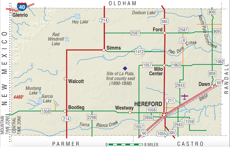
Deaf Smith County, on the western edge of the Panhandle, is bounded on the west by New Mexico, on the north by Oldham County, on the east by Randall County, and on the south by Parmer and Castro counties. It was named for Erastus "Deaf" Smith, a famous scout of the Texas Revolution. The county's center point is at 102°30' west longitude and 35°00' north latitude. Deaf Smith County comprises approximately 1,497 square miles of level prairies and rolling plains on the western edge of the Llano Estacado. Its loam soils, ranging from deep chocolate to sandy, support abundant native grasses as well as numerous agricultural products. Elevations range from 3,200 to 4,200 feet above sea level; the minimum average temperature is 22° F in January, and the average annual maximum is 93° in July. The average annual rainfall is 17.37 inches, and the annual growing season averages 185 days. Tierra Blanca Creek flows intermittently across the southern part of the county, and Palo Duro and North Palo Duro creeks run across the northeastern portion of the county. These streams enter the Red River basin in or near Palo Duro Canyon, in Randall County.
The earliest prehistoric inhabitants of these prairies gave way to Plains Apaches, who in turn were forced out by the warlike Comanches and Kiowas. In 1787, and again in 1788, José Mares followed Tierra Blanca Creek in his search for a route from Santa Fe to San Antonio. The Indian wars of the 1870s, culminating in the Red River War of 1874–75, led to the nomadic red man's removal to the Indian Territory. Shortly thereafter ranchers began to appear in the area, and in 1876 the Texas legislature formed Deaf Smith County from the Bexar District. The census counted thirty-eight people in the county in 1880.
H. Allen Anderson | © TSHA

Adapted from the official Handbook of Texas, a state encyclopedia developed by Texas State Historical Association (TSHA). It is an authoritative source of trusted historical records.

- ✅ Adoption Status:
- This place is available for adoption! Available for adoption!
- Adopted by:
- Your name goes here
- Dedication Message:
- Your message goes here
Currently Exists
Yes
Place type
Deaf Smith County is classified as a County
Altitude Range
3650 ft – 4460 ft
Size
Land area does not include water surface area, whereas total area does
- Land Area: 1,496.9 mi²
- Total Area: 1,498.4 mi²
Temperature
January mean minimum:
22.5°F
July mean maximum:
91.4°F
Rainfall, 2019
20.1 inches
Population Count, 2019
18,546
Civilian Labor Count, 2019
7,892
Unemployment, 2019
4.0%
Property Values, 2019
$2,442,996,365 USD
Per-Capita Income, 2019
$40,470 USD
Retail Sales, 2019
$411,047,469 USD
Wages, 2019
$89,518,982 USD
County Map of Texas
Deaf Smith County
- Deaf Smith County
Places of Deaf Smith County
| Place | Type | Population (Year/Source) | Currently Exists |
|---|---|---|---|
| Town | – | – | |
| Town | – | – | |
| Town | – | – | |
| Town | – | – | |
| Town | – | – | |
| Town | 10 (2014) | Yes | |
| Town | 52 (2014) | Yes | |
| Town | – | – | |
| Town | – | – | |
| Town | 25 (2014) | Yes | |
| Town | – | – | |
| Town | 10 (2014) | Yes | |
| Town | – | – | |
| Town | – | – | |
| Town | 14,779 (2021) | Yes | |
| Town | – | – | |
| Town | – | – | |
| Town | 5 (2014) | Yes | |
| Town | – | – | |
| Town | 6 (2014) | Yes | |
| Town | 5 (2014) | Yes | |
| Town | 15 (2014) | Yes | |
| Town | – | – |

Proud to call Texas home?
Put your name on the town, county, or lake of your choice.
Search Places »

