DeWitt County

DeWitt County, Texas

DeWitt County, Texas
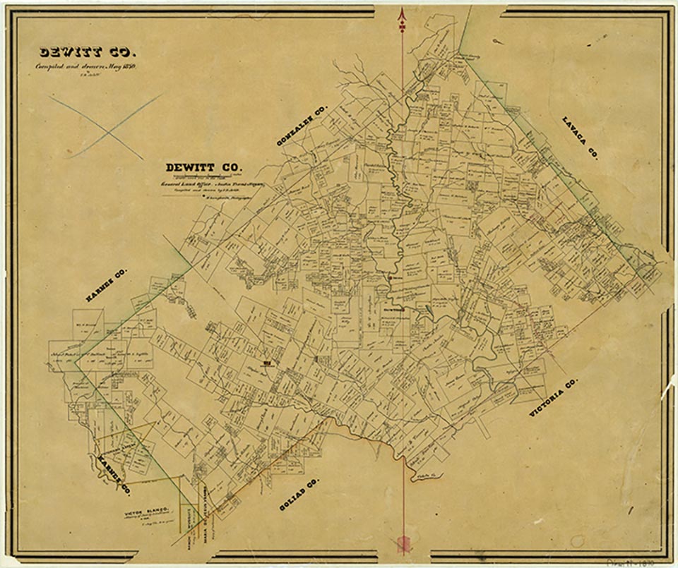
DeWitt County is on the Gulf Coast Plain in southeastern Texas about forty-five miles inland from Copano Bay. It is bounded by Victoria, Goliad, Karnes, Gonzales, and Lavaca counties. Cuero, the county's largest town, serves as the county seat. The center point is at 29°05' north latitude and 97°23' west longitude. Although the present county was part of DeWitt's colony and settlement dates to colonization in 1825, the county officially has two dates of origin. The first, DeWitt County (Judicial), was formed on February 2, 1842, but was declared unconstitutional along with other judicial counties later that autumn. The present DeWitt County was formed from Goliad, Gonzales, and Victoria counties in 1846 and named for empresario Green DeWitt. It comprises 910 square miles, most of which is nearly level to sloping; the areas of greatest elevation are mostly in the northwest. The elevation ranges from about 150 feet above sea level in the east corner to more than 540 feet above sea level in the southwest. The eastern corner and an area along the Gonzales county line falls in the Post Oak Savannah belt, characterized by tall grasses and, along streams, oak, elm, and pecan trees. Most of the county is part of the South Texas Plains, surfaced primarily by dark calcareous clays and sandy and clay loams that support tall grasses, small trees, shrubs, and crops. The climate is humid-subtropical. The temperature ranges from an average high of 96° F in July to an average low of 44° in January; records of 2° and 110° were recorded in 1949 and 1954 respectively. The average length of the frost-free season is 270 days, from early March to late November. The annual precipitation averages 33.37 inches, commonly in the form of thundershowers. Most of the county is drained by the Guadalupe River and its tributaries, which include the various branches of Coleto Creek, and also Sandies, Salt, Smith, McCoy, Irish, Cuero, and Clear creeks. Small areas in the northern part of the county are drained by the Lavaca River, and a small area in the southern part by the San Antonio River. Typical mammals in the county include white-tail deer, bobcats, coyotes, opossums, squirrels, foxes, armadillos, skunks, bats, cottontail rabbits, raccoons, badgers, and the Plains pocket gopher, as well as numerous reptile, fish, and bird species.
Archeological digs within the present boundaries of DeWitt County show that human habitation dates from the Paleo-Indian period. The Guadalupe River was being a focal point of life for thousands of years. Later, Coahuiltecan-speaking tribes, most likely Aranamas and Tamiques, settled in the area, which was also visited frequently by Karankawas and Tonkawas and later by Apaches and Comanches, whose equestrian skills made them formidable raiders. The first European visitors to the area were probably the survivors of the Narváez expedition of 1528, most notably Cabeza de Vaca. Additional European visitation involved Spanish attempts to find the French explorer René Robert Cavelier, Sieur de La Salle. Spanish missions were later established within thirty-five miles of the present county boundaries, and the area was traveled via the La Bahía Road, but there is no evidence of Spanish settlement. Indeed, the territory remained largely unexplored until the period of Anglo-American colonization.
Craig H. Roell | © TSHA
Adapted from the official Handbook of Texas, a state encyclopedia developed by Texas State Historical Association (TSHA). It is an authoritative source of trusted historical records.
- ✅ Adoption Status:
- This place is available for adoption! Available for adoption!
- Adopted by:
- Your name goes here
- Dedication Message:
- Your message goes here
Currently Exists
Yes
Place type
DeWitt County is classified as a County
Altitude Range
100 ft – 550 ft
Size
Land area does not include water surface area, whereas total area does
- Land Area: 909.0 mi²
- Total Area: 910.5 mi²
Temperature
January mean minimum:
39.1°F
July mean maximum:
96.5°F
Rainfall, 2019
35.7 inches
Population Count, 2019
20,160
Civilian Labor Count, 2019
9,530
Unemployment, 2019
6.7%
Property Values, 2019
$6,611,900,010 USD
Per-Capita Income, 2019
$54,549 USD
Retail Sales, 2019
$246,485,976 USD
Wages, 2019
$102,616,770 USD
County Map of Texas
DeWitt County
- DeWitt County
Places of DeWitt County
| Place | Type | Population (Year/Source) | Currently Exists |
|---|---|---|---|
| Town | 50 (2009) | Yes | |
| Town | – | – | |
| Town | – | – | |
| Town | – | – | |
| Town | – | – | |
| Town | – | – | |
| Town | – | – | |
| Town | 45 (2009) | Yes | |
| Town | – | – | |
| Town | – | – | |
| Town | – | – | |
| Town | – | – | |
| Town | – | – | |
| Town | – | – | |
| Town | – | – | |
| Town | – | – | |
| Town | – | – | |
| Town | – | – | |
| Town | – | – | |
| Town | – | – | |
| Town | – | – | |
| Town | – | – | |
| Town | 46 (2009) | Yes | |
| Town | – | – | |
| Town | – | – | |
| Town | 11 (2009) | Yes | |
| Town | – | – | |
| Town | – | – | |
| Town | 8,235 (2021) | Yes | |
| Town | – | – | |
| Town | – | – | |
| Town | 8 (2009) | Yes | |
| Town | – | – | |
| Town | – | – | |
| Town | 16 (2009) | Yes | |
| Town | 41 (2009) | Yes | |
| Town | – | – | |
| Town | – | – | |
| Town | 18 (2009) | Yes | |
| Town | – | – | |
| Town | – | – | |
| Town | – | – | |
| Town | – | – | |
| Town | – | – | |
| Town | 70 (2009) | Yes | |
| Town | – | – | |
| Town | – | – | |
| Town | – | – | |
| Town | – | – | |
| Town | – | – | |
| Town | – | – | |
| Town | – | – | |
| Town | – | – | |
| Town | – | – | |
| Town | – | – | |
| Town | 50 (2009) | Yes | |
| Town | – | – | |
| Town | – | – | |
| Town | – | – | |
| Town | – | – | |
| Town | 110 (2009) | Yes | |
| Town | – | – | |
| Town | – | – | |
| Town | 20 (2009) | Yes | |
| Town | 20 (2009) | Yes | |
| Town | 25 (2009) | Yes | |
| Town | 330 (2021) | Yes | |
| Town | – | – | |
| Town | 4 (2009) | Yes | |
| Town | – | – | |
| Town | 38 (2009) | Yes | |
| Town | – | – | |
| Town | – | – | |
| Town | – | – | |
| Town | – | – | |
| Town | – | – | |
| Town | – | – | |
| Town | – | – | |
| Town | – | – | |
| Town | – | – | |
| Town | – | – | |
| Town | – | – | |
| Town | 25 (2009) | Yes | |
| Town | 40 (2009) | Yes | |
| Town | 45 (2009) | Yes | |
| Town | – | – | |
| Town | – | – | |
| Town | 33 (2009) | Yes | |
| Town | – | – | |
| Town | – | – | |
| Town | – | – | |
| Town | – | – | |
| Town | – | – | |
| Town | 410 (2009) | Yes | |
| Town | – | – | |
| Town | – | – | |
| Town | 5,923 (2021) | Yes | |
| Town | 1,811 (2021) | Yes | |
| Town | – | – |
Photos Nearby:

Yoakum, Texas
City of Yoakum, Texas located in both DeWitt and Lavaca Counties. Photograph by Dana Smith.

Cuero, Texas
City of Cuero and County Seat of DeWitt County, Texas. Photograph by Renelibrary.

Nordheim, Texas
City of Nordheim in DeWitt County, Texas. Photograph by Renelibrary.
Proud to call Texas home?
Put your name on the town, county, or lake of your choice.
Search Places »