Erath County

Erath County, Texas

Erath County, Texas
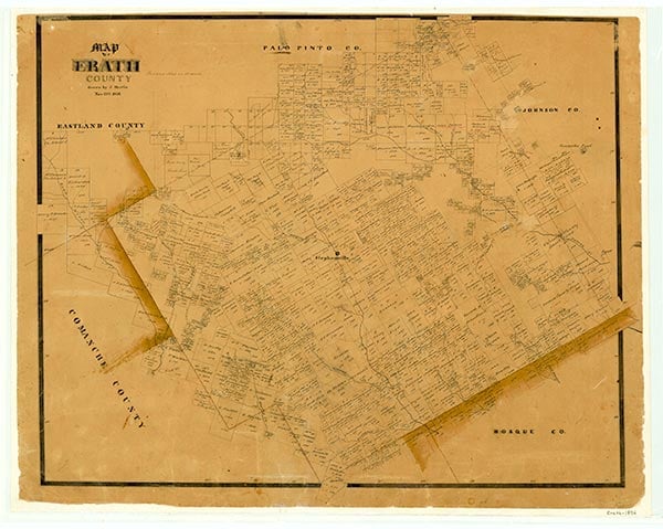
Erath County (EE-rath) was marked off from Bosque and Coryell counties in 1856 and named for George B. Erath, one of the original surveyors of the area. The center of the county is near Stephenville, eighty miles southwest of Dallas (at 32°10' N, 98°15' W). The county comprises 1,983 square miles and is divided into two distinct regions. The Western Cross Timbers, dominated by such hardwoods as post oak and a soil surface of sandy and red clay, crosses the northwestern two-thirds of the county, while the Grand Prairie, with dark limy soils originally covered with little bluestem but now dotted with live oak groves, crosses the southeastern one-third. The northern part of the county, where Cretaceous sediment has eroded, is noted for deposits of bituminous coal, fireclay, oil, and natural gas. The sand of the southern part is of glass-making quality. The animal life of Erath County includes badgers, civet cats, grey foxes, minks, wolves, mockingbirds, woodpeckers, and quail. The county's altitude ranges from 900 to 1,750 feet; the rainfall averages twenty-nine inches a year; the average temperature ranges from a low of 34° F during January to 96° in July, and the growing season lasts 238 days. The two major streams, the Paluxy and Bosque rivers, are tributaries of the Brazos. Transportation in Erath County is provided by Interstate Highway 20, which crosses the northwest corner, and U.S. highways 67, 281 and 377. The Fort Worth and Western Railroad crosses the central and southwestern parts of the county.
The first attempts at settlement were made in 1854 by A. H. Dobkins and Will and Tom Holland near the site of present-day Dublin. In the following year a party of thirty pioneers was brought into the area by surveyors George Erath and Neil McLennan. Included in the group were John M. Stephen, his brother William F., and eighteen slaves. The Stephens moved to the 4,409 acres of the John Blair survey, and the slaves may have been left alone in the post oak grove on the Bosque River, now the site of Stephenville, to establish relations with Caddo and Anadarko Indians, who still visited the area from their new reservation in what is now Young County. In 1856 John M. Stephen offered to donate land for a courthouse and townsite if the town was named Stephenville and made the county seat. The state of Texas agreed and formed Erath County that year.
Dan M. Young | © TSHA
Adapted from the official Handbook of Texas, a state encyclopedia developed by Texas State Historical Association (TSHA). It is an authoritative source of trusted historical records.
- ✅ Adoption Status:
- This place is available for adoption! Available for adoption!
- Adopted by:
- Your name goes here
- Dedication Message:
- Your message goes here
Currently Exists
Yes
Place type
Erath County is classified as a County
Altitude Range
820 ft – 1670 ft
Size
Land area does not include water surface area, whereas total area does
- Land Area: 1,083.1 mi²
- Total Area: 1,089.8 mi²
Temperature
January mean minimum:
31.0°F
July mean maximum:
94.2°F
Rainfall, 2019
31.5 inches
Population Count, 2019
42,698
Civilian Labor Count, 2019
19,968
Unemployment, 2019
6.7%
Property Values, 2019
$5,778,781,040 USD
Per-Capita Income, 2019
$39,572 USD
Retail Sales, 2019
$593,225,575 USD
Wages, 2019
$172,494,052 USD
County Map of Texas
Erath County
- Erath County
Places of Erath County
| Place | Type | Population (Year/Source) | Currently Exists |
|---|---|---|---|
| Town | – | – | |
| Town | – | – | |
| Town | 40 (2009) | Yes | |
| Town | – | – | |
| Town | – | – | |
| Town | – | – | |
| Town | – | – | |
| Town | – | – | |
| Town | – | – | |
| Town | – | – | |
| Town | 82 (2021) | Yes | |
| Town | – | – | |
| Town | 20 (2009) | Yes | |
| Town | – | – | |
| Town | – | – | |
| Town | 25 (2009) | Yes | |
| Town | 55 (2009) | Yes | |
| Town | – | – | |
| Town | – | – | |
| Town | – | – | |
| Town | – | – | |
| Town | – | – | |
| Town | – | – | |
| Town | 3,433 (2021) | Yes | |
| Town | 76 (2009) | Yes | |
| Town | – | – | |
| Town | 32 (2009) | Yes | |
| Town | – | – | |
| Town | – | – | |
| Town | – | – | |
| Town | – | – | |
| Town | – | – | |
| Town | – | – | |
| Town | – | – | |
| Town | – | – | |
| Town | – | – | |
| Town | – | – | |
| Town | 75 (2009) | Yes | |
| Town | – | – | |
| Town | 25 (2009) | Yes | |
| Town | 21 (2009) | Yes | |
| Town | – | – | |
| Town | 60 (2009) | Yes | |
| Town | – | – | |
| Town | – | – | |
| Town | 319 (2021) | Yes | |
| Town | – | – | |
| Town | – | – | |
| Town | – | – | |
| Town | – | – | |
| Town | 45 (2009) | Yes | |
| Town | – | – | |
| Town | 269 (2021) | Yes | |
| Town | – | – | |
| Town | – | – | |
| Town | – | – | |
| Town | – | – | |
| Town | 206 (2009) | Yes | |
| Town | – | – | |
| Town | – | – | |
| Town | – | – | |
| Town | – | – | |
| Town | 10 (2009) | Yes | |
| Town | – | – | |
| Town | – | – | |
| Town | – | – | |
| Town | 50 (2009) | Yes | |
| Town | – | – | |
| Town | – | – | |
| Town | – | – | |
| Town | – | – | |
| Town | – | – | |
| Town | – | – | |
| Town | 55 (2009) | Yes | |
| Town | – | – | |
| Town | – | – | |
| Town | – | – | |
| Town | 21,199 (2021) | Yes | |
| Town | – | – | |
| Town | – | – | |
| Town | – | – | |
| Town | 48 (2009) | Yes | |
| Town | – | – | |
| Town | – | – | |
| Town | – | – | |
| Town | – | – | |
| Town | – | – | |
| Town | – | – | |
| Town | – | – | |
| Town | – | – | |
| Town | – | – |
Photos Nearby:

Dublin, Texas
Ben Hogan Museum in Downtown Dublin, Texas. Photograph by Renelibrary.

Thurber, Texas
View of the Industrial Museum located in Thurber, Texas.
Photograph Credit: Robert Plocheck.

Stephenville, Texas
City Hall in the City of Stephenville, the county seat of Erath County, Texas. Photograph by Larry D. Moore.
Proud to call Texas home?
Put your name on the town, county, or lake of your choice.
Search Places »