Hardin County

Hardin County, Texas

Hardin County, Texas
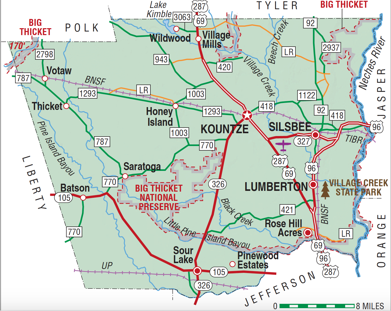
Hardin County, in the Big Thicket of Southeast Texas, is part of the larger East Texas Timberlands region. The county's center is sixty-eight miles northeast of Houston, twenty-three miles northwest of Beaumont, and fifty-four miles from the Gulf of Mexico (at 30°20' N, 94°23' W). Although pine and hardwood forests dominate the county's 897 square miles, grasses, native legumes, and dense undergrowths of brush and vines also thrive. Among numerous mammalian species, cougars and bears are sometimes sighted in the forests. Only a small section, in the southwestern corner of the county, is prairie. Pine Island and Little Pine Island bayous join Village and Cypress creeks to drain the area into the Neches River, which forms the eastern county line. Surface soils consist of a sandy loam, and the subsoil is red clay. Quicksand pits are found within forested areas. The elevation rises from thirty to 200 feet; the terrain is level in the west and undulating in the east. The average annual rainfall is fifty-three inches. The average low temperature is 42° in January, and the average high is 93° in July. The growing season lasts 246 days. In addition to timber, oil and gas, sand, gravel, and salt domes are found within the county.
Seeking the healing powers of the mud and mineral waters of a two-acre pond known to them as Medicine Lake, East Texas Indians began to visit the Sour Lake area of Hardin County long before the region became a part of the Atascosito District of Spanish and Mexican Texas. Empresario Lorenzo de Zavala received the territory as part of his colonization grant of 1829 but made little headway in persuading potential immigrants to settle there. Although a small community called Providence developed around 1830 a few miles north of the site of present Kountze, further efforts at colonization did not begin until 1834 and 1835. During those years the Mexican government made more than fifty land grants within the future Hardin County. Additional towns developed to serve the rural population and to attract weary travelers. Before the end of 1835 Stephen Jackson had founded a settlement at Sour Lake; by 1850 it was recognized as a health resort. Concord (now Loeb), a port town on Pine Island Bayou, developed soon after the Sour Lake settlement began. Saratoga, another health resort with medicinal springs, was also settled before the Civil War.
Patricia L. Duncan | © TSHA

Adapted from the official Handbook of Texas, a state encyclopedia developed by Texas State Historical Association (TSHA). It is an authoritative source of trusted historical records.

- ✅ Adoption Status:
- This place is available for adoption! Available for adoption!
- Adopted by:
- Your name goes here
- Dedication Message:
- Your message goes here
Currently Exists
Yes
Place type
Hardin County is classified as a County
Altitude Range
7 ft – 170 ft
Size
Land area does not include water surface area, whereas total area does
- Land Area: 890.6 mi²
- Total Area: 897.6 mi²
Temperature
January mean minimum:
37.5°F
July mean maximum:
93.6°F
Rainfall, 2019
61.1 inches
Population Count, 2019
57,602
Civilian Labor Count, 2019
24,129
Unemployment, 2019
10.5%
Property Values, 2019
$4,033,395,170 USD
Per-Capita Income, 2019
$45,982 USD
Retail Sales, 2019
$895,041,147 USD
Wages, 2019
$153,631,918 USD
County Map of Texas
Hardin County
- Hardin County
Places of Hardin County
| Place | Type | Population (Year/Source) | Currently Exists |
|---|---|---|---|
| Town | – | – | |
| Town | 140 (2014) | Yes | |
| Town | – | – | |
| Town | – | – | |
| Town | – | – | |
| Town | – | – | |
| Town | – | – | |
| Town | – | – | |
| Town | – | – | |
| Town | – | – | |
| Town | – | – | |
| Town | – | – | |
| Town | – | – | |
| Town | – | – | |
| Town | – | – | |
| Town | – | – | |
| Town | – | – | |
| Town | – | – | |
| Town | – | – | |
| Town | – | – | |
| Town | – | – | |
| Town | – | – | |
| Town | – | – | |
| Town | – | – | |
| Town | 200 (2014) | Yes | |
| Town | – | – | |
| Town | – | – | |
| Town | – | – | |
| Town | 2,163 (2021) | Yes | |
| Town | – | – | |
| Town | – | – | |
| Town | – | – | |
| Town | – | – | |
| Town | 13,802 (2021) | Yes | |
| Town | – | – | |
| Town | – | – | |
| Town | – | – | |
| Town | – | – | |
| Town | – | – | |
| Town | – | – | |
| Town | – | – | |
| Town | – | – | |
| Town | – | – | |
| Town | – | – | |
| Town | – | – | |
| Town | 1,407 (2021) | Yes | |
| Town | – | – | |
| Town | – | – | |
| Town | – | – | |
| Town | – | – | |
| Town | – | – | |
| Town | – | – | |
| Town | 328 (2021) | Yes | |
| Town | – | – | |
| Town | 1,000 (2014) | Yes | |
| Town | – | – | |
| Town | – | – | |
| Town | 6,851 (2021) | Yes | |
| Town | 1,792 (2021) | Yes | |
| Town | – | – | |
| Town | – | – | |
| Town | 306 (2009) | Yes | |
| Town | – | – | |
| Town | – | – | |
| Town | – | – | |
| Town | 200 (2014) | Yes | |
| Town | 160 (2014) | Yes | |
| Town | – | – | |
| Town | 732 (2021) | Yes | |
| Town | – | – | |
| Town | – | – |

Proud to call Texas home?
Put your name on the town, county, or lake of your choice.
Search Places »

