Jeff Davis County

Jeff Davis County, Texas

Jeff Davis County, Texas
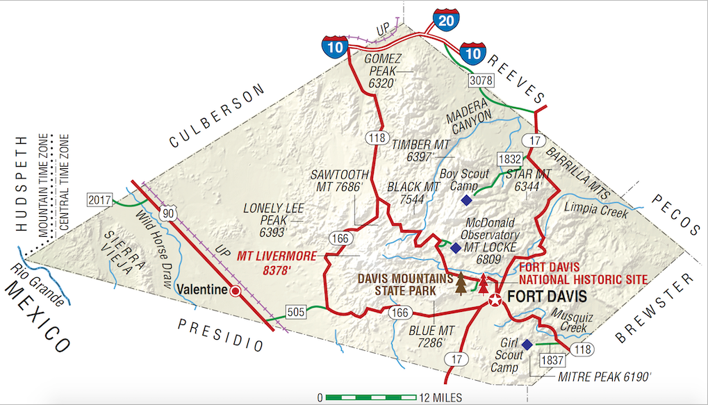
Jeff Davis County, in the Trans-Pecos region of west Texas, is bordered by Culberson County to the northwest, Reeves and Pecos counties to the northeast, Brewster County to the southeast, and Presidio County to the southwest; the westernmost point of Jeff Davis County touches the Rio Grande. Fort Davis, the county seat and largest town, is 175 miles southeast of El Paso in southeastern Jeff Davis County. The county's center is about twenty miles northwest of Fort Davis at approximately 30°45' north latitude and 104°10' west longitude. Interstate Highway 10, U.S. Highway 80, and the Union Pacific Railroad cross the northern tip of Jeff Davis County, U.S. Highway 90 and anothe branch of the Union Pacific Railroad cross the western part of the county. State Highway 17 runs from north to south through eastern Jeff Davis County, and State Highway 118 runs from northwest to southeast across the central part of the county. Jeff Davis County comprises 2,258 square miles, varying from mountainous to nearly level, with elevations ranging from 3,800 to 8,378 feet above sea level; the latter, at the top of Mount Livermore, is the fifth highest elevation in the state. Jeff Davis County is in the Rio Grande basin. Soils in this predominantly mountainous county are generally thin and stony; in the valleys dark loams overlie clayey subsoils. Vegetation in the county includes scrub brush, cacti, grasses, live oak, piñon, and juniper, with Douglas fir, aspen, maple, ponderosa pine, and madrone at the higher elevations. Among the animals found (and hunted) in the county are mule deer, white-tailed deer, pronghorn antelope, mountain lion, javelina, elk, coyote, bobcat, ringtailed cat, badger, fox, weasel, civet cat, raccoon, skunk, sandhill crane, jacksnipe, mourning dove, white-winged dove, and teal. Several animals considered rare or endangered in Texas are found in Jeff Davis County, including the silver-haired bat, shorthorn lizard, Steller's jay, Clark's nutcracker, and band-tailed pigeon. Mineral resources include barite, kaolin clay, lead, limestone, manganese, rhyolite, silver, fluorspar, and zeolite. The climate is subtropical-arid. The average minimum temperature in January is 32° F, and the average maximum temperature in July is 90°. The growing season averages 225 days a year, and the average annual precipitation is eighteen inches. Less than 1 percent of the land in the county is considered prime farmland.
Jeff Davis County is best known for the Davis Mountains, the highest mountain range located entirely within the state of Texas. Evidence of prehistoric peoples in these mountains includes a cache of some 1,200 Livermore arrow points, dating from around A.D. 1000. Prehistoric peoples camped at Phantom Lake Spring, in northeastern Jeff Davis County, and may have used the springs for irrigation. The earliest White man to set foot in what is now Jeff Davis County was Antonio de Espejo, who in 1583 trekked up Limpia Canyon and across the southwestern part of the county.
Martin Donell Kohout | © TSHA

Adapted from the official Handbook of Texas, a state encyclopedia developed by Texas State Historical Association (TSHA). It is an authoritative source of trusted historical records.

- ✅ Adoption Status:
Currently Exists
Yes
Place type
Jeff Davis County is classified as a County
Altitude Range
3162 ft – 8378 ft
Size
Land area does not include water surface area, whereas total area does
- Land Area: 2,264.6 mi²
- Total Area: 2,264.6 mi²
Temperature
January mean minimum:
28.9°F
July mean maximum:
88.7°F
Rainfall, 2019
17.5 inches
Population Count, 2019
2,274
Civilian Labor Count, 2019
930
Unemployment, 2019
5.6%
Property Values, 2019
$604,231,364 USD
Per-Capita Income, 2019
$42,947 USD
Retail Sales, 2019
$9,979,880 USD
Wages, 2019
$7,818,970 USD
County Map of Texas
Jeff Davis County
- Jeff Davis County
Places of Jeff Davis County
| Place | Type | Population (Year/Source) | Currently Exists |
|---|---|---|---|
| Town | – | – | |
| Town | – | – | |
| Town | – | – | |
| Town | – | – | |
| Town | 1,012 (2021) | Yes | |
| Town | – | – | |
| Town | – | – | |
| Town | – | – | |
| Town | – | – | |
| Town | – | – | |
| Town | – | – | |
| Town | – | – | |
| Town | – | – | |
| Town | – | – | |
| Town | – | – | |
| Town | 108 (2021) | Yes | |
| Town | – | – |

Proud to call Texas home?
Put your name on the town, county, or lake of your choice.
Search Places »

