Kenedy County

Kenedy County, Texas

Kenedy County, Texas
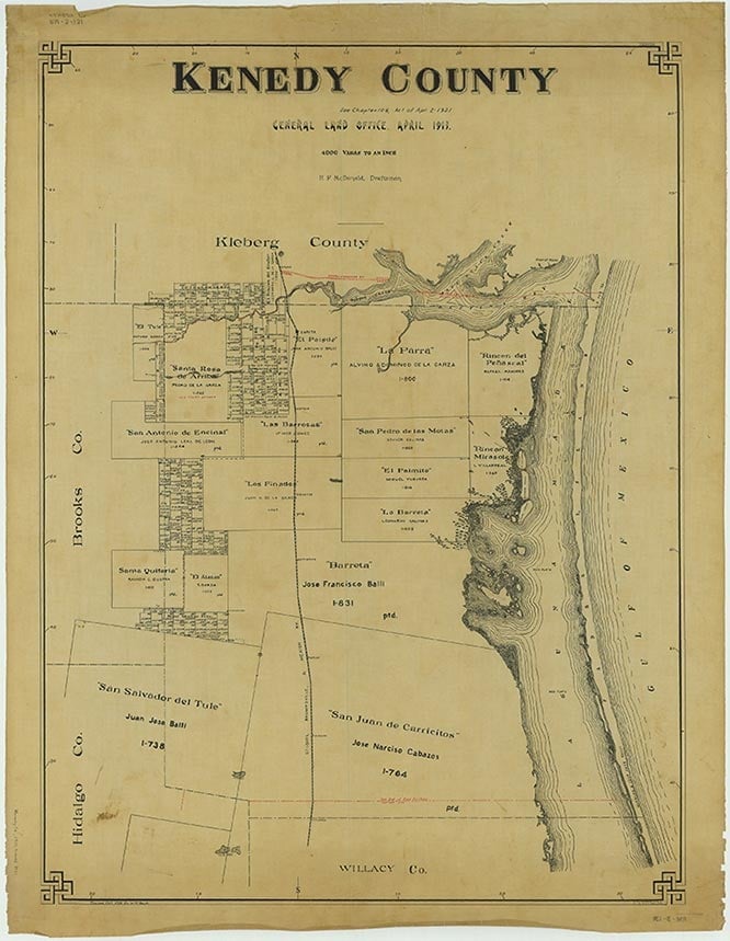
Kenedy County, on U.S. Highway 77 south of Corpus Christi in the Rio Grande Plain region of South Texas, was named for pioneer rancher Mifflin Kenedy. It is bordered by Kleberg County on the north, the Gulf of Mexico on the east, Willacy County on the south, and Hidalgo and Brooks counties on the west. The center point of the county is 26°55' north latitude and 97°40' west longitude. Sarita, in northern Kenedy County, is the county seat and largest town. Other communities include Armstrong, Turcotte, Norias, and Rudolph. The county comprises 1,389 square miles, with elevations ranging from sea level to 100 feet. The soils are generally sandy with areas of light-colored loamy surfaces over very deep reddish or mottled clayey subsoils. Along the Gulf Coast the soils are sandy and salty, with areas of gray to black, cracking clay. Less than 1 percent of the county is considered prime farmland. Most of Kenedy County is covered with brush and scrubby mesquite, with some huisache, acacia, post oak, and live oak. Tall bunchgrasses, such as the seacoast bluestem, are found along the coast, as well as cordgrasses, saltgrass, and marsh millet. Temperatures range from an average low of 47° F in January to an average high of 96° in July; the average annual temperature is 73°. Rainfall averages twenty-six inches a year, and the average growing season is 319 days. Mineral resources include oil and natural gas.
The area has been the site of human habitation for perhaps 11,000 years. Among the oldest artifacts found in the county are stone implements and human remains dating from the Paleo-Indian period (9200 to 6000 B.C.). During the Archaic period (6000 B.C. to A.D. 1000) the local Indian population seems to have increased, and small bands of hunter-gatherers apparently frequented the area, subsisting on game, wild fruits, seeds, and roots. These early peoples carved tools from wood and stone, wove baskets, and made rabbitskin clothing. The hunting and gathering way of life persisted into the Late Prehistoric period (A.D. 1000 to the arrival of the Spanish), though during this time the Indians in the area, who belonged to the Coahuiltecan linguistic group, learned to make pottery and hunted with bows and arrows. By the early 1800s the local Coahuiltecans had succumbed to disease, intermarried with the Spanish, or been driven out by the Lipan Apaches.
Alicia A. Garza | © TSHA
Adapted from the official Handbook of Texas, a state encyclopedia developed by Texas State Historical Association (TSHA). It is an authoritative source of trusted historical records.
- ✅ Adoption Status:
- This place is available for adoption! Available for adoption!
- Adopted by:
- Your name goes here
- Dedication Message:
- Your message goes here
Currently Exists
Yes
Place type
Kenedy County is classified as a County
Altitude Range
0 ft – 115 ft
Size
Land area does not include water surface area, whereas total area does
- Land Area: 1,458.3 mi²
- Total Area: 1,945.8 mi²
Temperature
January mean minimum:
44.4°F
July mean maximum:
94.6°F
Rainfall, 2019
29.2 inches
Population Count, 2019
404
Civilian Labor Count, 2019
182
Unemployment, 2019
6.6%
Property Values, 2019
$1,864,023,045 USD
Per-Capita Income, 2019
$43,561 USD
Wages, 2019
$10,244,184 USD
County Map of Texas
Kenedy County
- Kenedy County
Places of Kenedy County
| Place | Type | Population (Year/Source) | Currently Exists |
|---|---|---|---|
| Town | 4 (2009) | Yes | |
| Town | – | – | |
| Town | – | – | |
| Town | – | – | |
| Town | – | – | |
| Town | – | – | |
| Town | – | – | |
| Town | – | – | |
| Town | 164 (2021) | Yes | |
| Town | – | – | |
| Town | – | – |
Proud to call Texas home?
Put your name on the town, county, or lake of your choice.
Search Places »