Lamb County

Lamb County, Texas.

Lamb County, Texas.
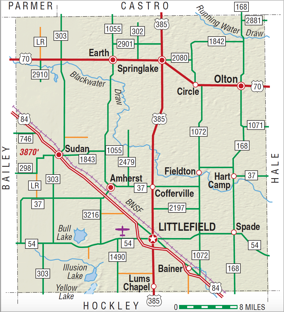
Lamb County is on the southern edge of the Panhandle, in the South Plains portion of the state, bordered on the east by Hale County, on the south by Hockley County, on the west by Bailey County, and on the north by Castro and Parmer counties. The center of the county is located at 34°02' north latitude and 102°20' west longitude. The entire county is atop the high plains. Littlefield, the county seat, is in the southern part of the county on U.S. Highway 84, forty miles northwest of Lubbock. The county was named for George A. Lamb. It occupies 1,022 square miles of level plains dotted with playas and a few low hills. Soils range from sandy to brown and support a variety of agricultural crops, including grain sorghum, cotton, corn, wheat, and soybeans. A relatively small amount of oil production occurs in the southern part of the county. The major physical features of the county are the dry bed of the North Fork of the Double Mountain Fork of the Brazos River, also known as Blackwater Draw, and a range of low-lying sand hills roughly following the course of Blackwater Draw as it meanders southeast across the northern section of the county. Two other tributaries of the Brazos, Running Water Creek and Yellow House River, also traverse the county. Four small lakes are found in the western half of the county: Soda Lake in the northwest and Bull Lake, Illusion Lake, and Yellow Lake in the southwest. Elevations in Lamb County range from 3,400 to 3,800 feet above sea level. Annual precipitation averages 18.04 inches per year, and the growing season lasts 194 days. Temperatures range between an average minimum temperature of 24° F in January and an average maximum of 93° in July.
The South Plains of Texas was long the domain of Apachean peoples until they were pushed out of the region by the more warlike Comanches around 1700. The Comanches ruled the Panhandle-Plains until the Red River War of 1873–74, when they were crushed by the United States Army. In 1875 the Comanches left the Panhandle-Plains for reservations in Indian Territory, leaving the region to the buffalo hunters. Between 1876 and 1880 the huge buffalo herds on the Texas Plains were almost exterminated, leaving the area open for occupation by cattlemen. Lamb County was established by the Texas legislature in 1876 from lands previously assigned to Bexar County.
Donald R. Abbe | © TSHA

Adapted from the official Handbook of Texas, a state encyclopedia developed by Texas State Historical Association (TSHA). It is an authoritative source of trusted historical records.

- ✅ Adoption Status:
Currently Exists
Yes
Place type
Lamb County is classified as a County
Altitude Range
3390 ft – 3870 ft
Size
Land area does not include water surface area, whereas total area does
- Land Area: 1,016.2 mi²
- Total Area: 1,017.7 mi²
Temperature
January mean minimum:
24.5°F
July mean maximum:
92.0°F
Rainfall, 2019
18.9 inches
Population Count, 2019
12,893
Civilian Labor Count, 2019
4,982
Unemployment, 2019
5.9%
Property Values, 2019
$1,278,693,116 USD
Per-Capita Income, 2019
$38,247 USD
Retail Sales, 2019
$145,187,455 USD
Wages, 2019
$48,778,884 USD
County Map of Texas
Lamb County
- Lamb County
Places of Lamb County
| Place | Type | Population (Year/Source) | Currently Exists |
|---|---|---|---|
| Town | 664 (2021) | Yes | |
| Town | 10 (2009) | Yes | |
| Town | – | – | |
| Town | 6 (2009) | Yes | |
| Town | 4 (2009) | Yes | |
| Town | – | – | |
| Town | 901 (2021) | Yes | |
| Town | – | – | |
| Town | 20 (2009) | Yes | |
| Town | – | – | |
| Town | 4 (2009) | Yes | |
| Town | – | – | |
| Town | 5,871 (2021) | Yes | |
| Town | 6 (2009) | Yes | |
| Town | 1,967 (2021) | Yes | |
| Town | – | – | |
| Town | – | – | |
| Town | 55 (2021) | Yes | |
| Town | 140 (2021) | Yes | |
| Town | 939 (2021) | Yes | |
| Town | – | – | |
| Town | – | – |

Proud to call Texas home?
Put your name on the town, county, or lake of your choice.
Search Places »

