Limestone County

Limestone County, Texas

Limestone County, Texas
Limestone County is in Central Texas about thirty miles due east of Waco. Mexia, its largest community, is approximately eighty miles south of Dallas. Groesbeck, the county seat, is near the county's center, at approximately 31°31' north latitude and 96°35' west longitude. The county comprises 931 square miles principally in the Blackland Prairies region. In the southeastern section loamy soils overlie mottled gray and red or yellow, cracking, clayey subsoils; in the central section the soils are slightly acidic and loamy at the surface, with cracking clayey subsoils; and surfaces in the northwestern section are dark, calcareous, mostly cracking, clayey soils. The nearly level to undulating terrain and light-colored, medium to slightly acid soils of the Claypan area and Cross Timbers are also found in the county. The vegetation includes mesquite, blackjack oak, pecan, bois d'arc, and elm trees as well as Indian grass and Texas winter grass in the northern area; the Post Oak Savannah vegetation of the southern area has tall grasses, Post oak, and blackjack oak. The natural resources of the county are clays, including kaolin and ceramic clays, limestone, industrial sand, glauconite, lignite coal, oil, and gas. The level to rolling prairie ranges from 375 to 665 feet above sea level. The land, on the divide between the Brazos and Trinity rivers, is drained by the Navasota River and its tributaries, which split the county in two. Bodies of water include Lake Mexia, Springfield Lake, and Lake Limestone. The average annual precipitation is almost thirty-eight inches, and the temperatures range from an average low of 37° F in January to an average high of 96° in July. The average growing season lasts 255 days.
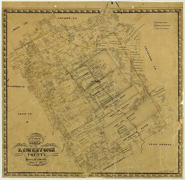
The area that became Limestone County was home to the Tawakoni, or Tehuacana, and Waco Indians. These were primarily agrarian people friendly to the whites who settled there. Tehuacana, in northeastern Limestone County, is on an old Indian village site. The Tawakonis were expert hunters and noted traders as well. Their enemies were the Apaches and Comanches, who often raided the Tawakoni settlements. Limestone County was part of the Haden Edwards and Robert Leftwich empresario grants made by the Coahuila and Texas legislature in 1825. This legislation began settlement of the area and the struggle between the government of Mexico and the American settlers for dominance. The government tried to restrict colonization through legislation, but settlers continued to come to Texas. Numerous individuals, both Mexican and Anglo, claimed land grants in the area before 1836. Among these were Silas M. Parker, Moses Herrin, Elisha Anglin, Luther T. M. Plummer, David Faulkenberry, Joshua Hadley, and Samuel Frost, who came together as a group from Illinois in 1833 to establish a permanent settlement for their families. Fort Parker, near the Navasota River in what is now central Limestone County, was the earliest actual settlement in the vicinity. While most of the men were out in the fields early on May 19, 1836, a large band of Comanches and their Kiowa allies approached the fort. After a short conversation under a flag of truce, the Indians attacked and killed most of the inhabitants. Several prisoners were taken, including Mrs. Rachel Plummer, who later wrote an account of her captivity, and nine-year-old Cynthia Ann Parker, who spent the next twenty-four years with the Comanches and married Peta Nocona. Their son, Quanah Parker, was a chief of the tribe. The other eighteen survivors wandered for six days, hiding in the riverbottoms, until they reached Fort Houston, from where a rescue party was sent back to survey the scene. After this raid further settlement was delayed until a treaty with the Indians was signed in 1844 at the instigation of Sam Houston.
Ellen Maschino | © TSHA
Adapted from the official Handbook of Texas, a state encyclopedia developed by Texas State Historical Association (TSHA). It is an authoritative source of trusted historical records.
- ✅ Adoption Status:
- This place is available for adoption! Available for adoption!
- Adopted by:
- Your name goes here
- Dedication Message:
- Your message goes here
Currently Exists
Yes
Place type
Limestone County is classified as a County
Altitude Range
363 ft – 690 ft
Size
Land area does not include water surface area, whereas total area does
- Land Area: 905.3 mi²
- Total Area: 933.2 mi²
Temperature
January mean minimum:
35.2°F
July mean maximum:
94.1°F
Rainfall, 2019
40.3 inches
Population Count, 2019
23,437
Civilian Labor Count, 2019
8,354
Unemployment, 2019
8.0%
Property Values, 2019
$3,041,561,950 USD
Per-Capita Income, 2019
$35,771 USD
Retail Sales, 2019
$247,823,162 USD
Wages, 2019
$92,540,850 USD
County Map of Texas
Limestone County
- Limestone County
Places of Limestone County
| Place | Type | Population (Year/Source) | Currently Exists |
|---|---|---|---|
| Town | – | – | |
| Town | – | – | |
| Town | – | – | |
| Town | 42 (2009) | Yes | |
| Town | – | – | |
| Town | 12 (2009) | Yes | |
| Town | – | – | |
| Town | 9 (2009) | Yes | |
| Town | – | – | |
| Town | 45 (2009) | Yes | |
| Town | 21 (2009) | Yes | |
| Town | – | – | |
| Town | 10 (2009) | Yes | |
| Town | – | – | |
| Town | – | – | |
| Town | – | – | |
| Town | 76 (2009) | Yes | |
| Town | – | – | |
| Town | – | – | |
| Town | – | – | |
| Town | – | – | |
| Town | – | – | |
| Town | 25 (2009) | Yes | |
| Town | – | – | |
| Town | – | – | |
| Town | 777 (2021) | Yes | |
| Town | – | – | |
| Town | – | – | |
| Town | 2 (2009) | Yes | |
| Town | 17 (2009) | Yes | |
| Town | 20 (2009) | Yes | |
| Town | – | – | |
| Town | 50 (2009) | Yes | |
| Town | – | – | |
| Town | – | – | |
| Town | – | – | |
| Town | – | – | |
| Town | – | – | |
| Town | – | – | |
| Town | – | – | |
| Town | – | – | |
| Town | – | – | |
| Town | 15 (2009) | Yes | |
| Town | 100 (2009) | Yes | |
| Town | 51 (2009) | Yes | |
| Town | – | – | |
| Town | 340 (2009) | Yes | |
| Town | 2 (2009) | Yes | |
| Town | 30 (2009) | Yes | |
| Town | – | – | |
| Town | 3,645 (2021) | Yes | |
| Town | – | – | |
| Town | – | – | |
| Town | – | – | |
| Town | – | – | |
| Town | – | – | |
| Town | – | – | |
| Town | – | – | |
| Town | – | – | |
| Town | – | – | |
| Town | 10 (2009) | Yes | |
| Town | 454 (2021) | Yes | |
| Town | – | – | |
| Lake | – | Yes | |
| Lake | – | Yes | |
| Town | 30 (2009) | Yes | |
| Town | – | – | |
| Town | – | – | |
| Town | – | – | |
| Town | – | – | |
| Town | – | – | |
| Town | – | – | |
| Town | – | – | |
| Town | – | – | |
| Town | 2 (2009) | Yes | |
| Town | – | – | |
| Town | – | – | |
| Town | – | – | |
| Town | – | – | |
| Town | – | – | |
| Town | – | – | |
| Town | 6,876 (2021) | Yes | |
| Town | 9 (2009) | Yes | |
| Town | – | – | |
| Town | – | – | |
| Town | – | – | |
| Town | 5 (2009) | Yes | |
| Town | – | – | |
| Town | – | – | |
| Town | – | – | |
| Town | – | – | |
| Town | – | – | |
| Town | 24 (2009) | Yes | |
| Town | 25 (2009) | Yes | |
| Town | 53 (2009) | Yes | |
| Town | – | – | |
| Town | – | – | |
| Town | 50 (2009) | Yes | |
| Town | 20 (2009) | Yes | |
| Town | 200 (2009) | Yes | |
| Town | – | – | |
| Town | – | – | |
| Town | – | – | |
| Town | 150 (2009) | Yes | |
| Town | 20 (2009) | Yes | |
| Town | – | – | |
| Town | – | – | |
| Town | – | – | |
| Town | 5 (2009) | Yes | |
| Town | – | – | |
| Town | – | – | |
| Town | – | – | |
| Town | – | – | |
| Town | 250 (2009) | Yes | |
| Town | – | – | |
| Town | – | – | |
| Town | – | – | |
| Town | – | – | |
| Town | – | – | |
| Town | – | – | |
| Town | – | – | |
| Town | 224 (2021) | Yes | |
| Town | – | – | |
| Town | 20 (2009) | Yes | |
| Town | 415 (2021) | Yes | |
| Town | – | – | |
| Town | – | – | |
| Town | – | – | |
| Town | – | – | |
| Town | 25 (2009) | Yes | |
| Town | 25 (2009) | Yes | |
| Town | – | – | |
| Town | – | – | |
| Town | – | – | |
| Town | – | – | |
| Town | – | – |
Photos Nearby:

Groesbeck, Texas
Downtown view of the city of Groesbeck, the seat of Limestone County, Texas. Photograph by Renelibrary.
.jpg)

A colorful sunset on Lake Limestone
Photo by Judah Morford, Flickr, CC2
Proud to call Texas home?
Put your name on the town, county, or lake of your choice.
Search Places »