Palo Pinto County

Palo Pinto County, Texas
Photograph Credit: Robert Plocheck.

Palo Pinto County, Texas
Photograph Credit: Robert Plocheck.

Palo Pinto County, Texas.

Palo Pinto County, Texas
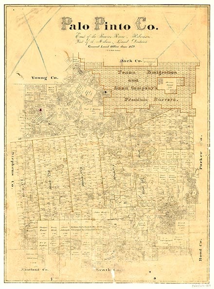
Palo Pinto County is in north central Texas, bounded on the east by Parker County, on the south by Erath County, on the west by Stephens County, and on the north by Young and Jack counties. The center of the county lies at 32°45' north latitude and 98°18' west longitude, eighty miles west of Fort Worth. The area is named for one of its principal streams. The county covers 948 square miles of broken, hilly land with sandy, gray, and black soils; elevations range between 800 to 1,450 feet above sea level. The county has an average annual rainfall of 30.13 inches and is drained by the Brazos River. Timber in the area includes cedar, oak, and pecan. Temperatures range from an average low of 33° F in January to an average high of 96° F in July; the growing season lasts 221 days. During the 1980s the county's annual agricultural yield was $12.5 million, 90 percent of which was from livestock, including cattle, sheep, angora goats, and hogs. Pecans, peaches, vegetables, grains, and hay accounted for the rest. Clay pipes, aircraft systems, plastics, electronic products, brick, feeds, clothes, and other products manufactured in the county earned an average annual income of $43.4 million. In 1982 oil sales of 364,350 barrels yielded $8.4 million. Major highways include U.S. Highway 180, which runs west to east across the county; Interstate Highway 20, which crosses the southeast corner; and State highways 16 and 108, which run north to south.
William A. A. (Bigfoot) Wallace surveyed the frontier in 1837 and may have been the first White in the area that is now Palo Pinto County. The original settlers in the region, including Oliver Loving, Charles Goodnight, and Reuben Vaughn, established cattle ranches there in the mid-to-late 1850s. These pioneers had Indian neighbors who raised corn and grain to supplement their game hunting; there were six groups of Indians, numbering 1,000 people, living along the Brazos in 1850. Though Vaughn and other early settlers apparently cultivated friendships with the Indians, as more Whites moved into the region the relations between the two peoples became strained, particularly because of the senseless aggression of some Whites. The Brazos Indian Reservation, founded in 1854, held destitute bands from several tribes-Delawares, Shawnees, Tonkawas, Wichitas, and Caddoes. All Indian depredations, whether perpetrated by free Comanches or Kiowas passing through the region or by reservation Indians from Indian Territory, were attributed by terrified settlers to Indians from the Brazos reservation. White settlers retaliated against reservation Indians, and racial tension and violent incidents increased. According to pioneer Henry Belding, reservation Indians became hostile "because a lot of cowards from Erath County had found a party of Indians camped near Palo Pinto and attacked...and killed squaws and children and men...[T]heir dastardly act cost the lives of many good citizens." Violence followed, and in 1856 the Texas Rangers rounded up the Indians and moved them to two reservations established in Young and Throckmorton counties. The removal did not end the conflict, however, for settlers complained that reservation Indians continued to steal cattle, and some settlers threatened to attack the reservations. Eventually the Indians were removed from their Brazos reservation to Oklahoma, while settlers flocked in along the old Fort Worth-Fort Belknap road.
John Leffler | © TSHA
Adapted from the official Handbook of Texas, a state encyclopedia developed by Texas State Historical Association (TSHA). It is an authoritative source of trusted historical records.
- ✅ Adoption Status:
Currently Exists
Yes
Place type
Palo Pinto County is classified as a County
Altitude Range
782 ft – 1530 ft
Size
Land area does not include water surface area, whereas total area does
- Land Area: 951.8 mi²
- Total Area: 985.5 mi²
Temperature
January mean minimum:
32.2°F
July mean maximum:
95.5°F
Rainfall, 2019
32.1 inches
Population Count, 2019
29,189
Civilian Labor Count, 2019
13,256
Unemployment, 2019
8.2%
Property Values, 2019
$4,466,912,294 USD
Per-Capita Income, 2019
$39,125 USD
Retail Sales, 2019
$353,713,228 USD
Wages, 2019
$101,779,888 USD
County Map of Texas
Palo Pinto County
- Palo Pinto County
Places of Palo Pinto County
| Place | Type | Population (Year/Source) | Currently Exists |
|---|---|---|---|
| Town | – | – | |
| Town | – | – | |
| Town | – | – | |
| Town | – | – | |
| Town | – | – | |
| Town | – | – | |
| Town | – | – | |
| Town | 16 (2009) | Yes | |
| Town | 173 (2021) | Yes | |
| Town | – | – | |
| Town | – | – | |
| Town | – | – | |
| Town | – | – | |
| Town | – | – | |
| Town | – | – | |
| Town | – | – | |
| Town | – | – | |
| Town | 18 (2009) | Yes | |
| Town | – | – | |
| Town | – | – | |
| Town | – | – | |
| Town | – | – | |
| Town | – | – | |
| Town | 474 (2021) | Yes | |
| Town | – | – | |
| Town | – | – | |
| Town | 685 (2021) | Yes | |
| Town | – | – | |
| Town | – | – | |
| Town | – | – | |
| Town | – | – | |
| Town | – | – | |
| Town | – | – | |
| Town | – | – | |
| Town | – | – | |
| Lake | – | Yes | |
| Town | – | – | |
| Town | 110 (2009) | Yes | |
| Town | – | – | |
| Town | – | – | |
| Town | – | – | |
| Town | 6 (2009) | Yes | |
| Town | 14,902 (2021) | Yes | |
| Town | 230 (2021) | Yes | |
| Town | – | – | |
| Town | 89 (2009) | Yes | |
| Town | 61 (2009) | Yes | |
| Town | – | – | |
| Town | 173 (2021) | Yes | |
| Town | 15 (2009) | Yes | |
| Town | – | – | |
| Town | – | – | |
| Town | – | – | |
| Town | – | – | |
| Lake | – | Yes | |
| Town | – | – | |
| Town | – | – | |
| Town | – | – | |
| Town | 88 (2009) | Yes | |
| Town | 308 (2021) | Yes | |
| Town | – | – | |
| Town | 549 (2021) | Yes | |
| Town | – | – | |
| Town | – | – | |
| Town | – | – | |
| Town | – | – | |
| Town | – | – | |
| Town | – | – | |
| Town | – | – |
Photos Nearby:

Mineral Wells, Texas
View of gorgeous fall foliage in Mineral Wells, Texas.
Photograph Credit: Robert Plocheck.

Palo Pinto, Texas
Dowtown view of the town of Palo Pinto, Texas.
Photograph Credit: Robert Plocheck.

Oran, Texas
View of the Old Oran Post Office in Palo Pinto County, Texas.
Photograph Credit: Robert Plocheck.

Children hiking near Possum Kingdom Lake
Photo by Loadmaster, CC by SA 3
Proud to call Texas home?
Put your name on the town, county, or lake of your choice.
Search Places »