Port Bolivar
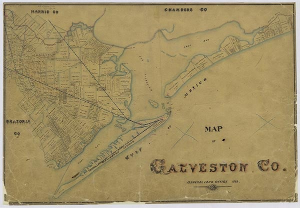
Port Bolivar is a community at the western tip of Bolivar Peninsula, a short ferry ride across the body of water known as Bolivar Roads from Galveston Island and the city of Galveston, in Galveston County. Port Bolivar is served by State Highway 87. The peninsula was once inhabited by Karankawa Indians, but White settlers arrived at the point as early as 1819, when James Long made headquarters there. Most of the early settlers gathered around Fort Travis. In 1838 Samuel D. Parr surveyed the area around the site of Port Bolivar. He was granted a league of land by the Republic of Texas. The town that grew up was known for a while as Parrsville, and a post office operated under that name from 1884 to 1892, when the community was renamed Pepper Grove. Parr is said to have sold 960 acres to Archibald Wynns and William Lawrence, who laid out a town they called Ismail or Ishmael and offered lots for sale. A post office operated at Point Bolivar in 1876 as Gabion. In 1893 a townsite company purchased 2,978 acres in the area and named its community Port Bolivar. The Gulf and Interstate Railway began operation between Port Bolivar and Beaumont in 1896. Barges moved freight cars and passengers across Bolivar Roads. Port Bolivar was one of the first ports established in Texas, and it played a lively role in the economic life of the area. Major local industries have included fish and seafood, lumber, cattle, and hides. Completion of an ore dock in 1912 offered the area promise as an industrial center. In 1915 Port Bolivar had a physician, two general stores, and 100 residents. In 1990 it had a population of 1,200, a school operated by the Galveston Independent School District, and twenty businesses. In 1994 the businesses numbered forty-three. At the Port Bolivar Recreation Center is a marker commemorating the heroism of Simón Bolívar, a gift in 1968 of the Republic of Venezuela. In 2000 the population was 1,200.
A. Pat Daniels | © TSHA
Adapted from the official Handbook of Texas, a state encyclopedia developed by Texas State Historical Association (TSHA). It is an authoritative source of trusted historical records.
- ✅ Adoption Status:
- This place is available for adoption! Available for adoption!
- Adopted by:
- Your name goes here
- Dedication Message:
- Your message goes here
Belongs to
Port Bolivar is part of or belongs to the following places:
Currently Exists
Yes
Place type
Port Bolivar is classified as a Town
Associated Names
- [Point-]
- (Fort Travis)
- (Gabion)
- (Parrsville)
- (Pepper Grove)
Location
Latitude: 29.38079010Longitude: -94.76436230
Has Post Office
Yes
Is Incorporated
No
Population Count, 2009
700