Port Lavaca

Port Lavaca, Texas

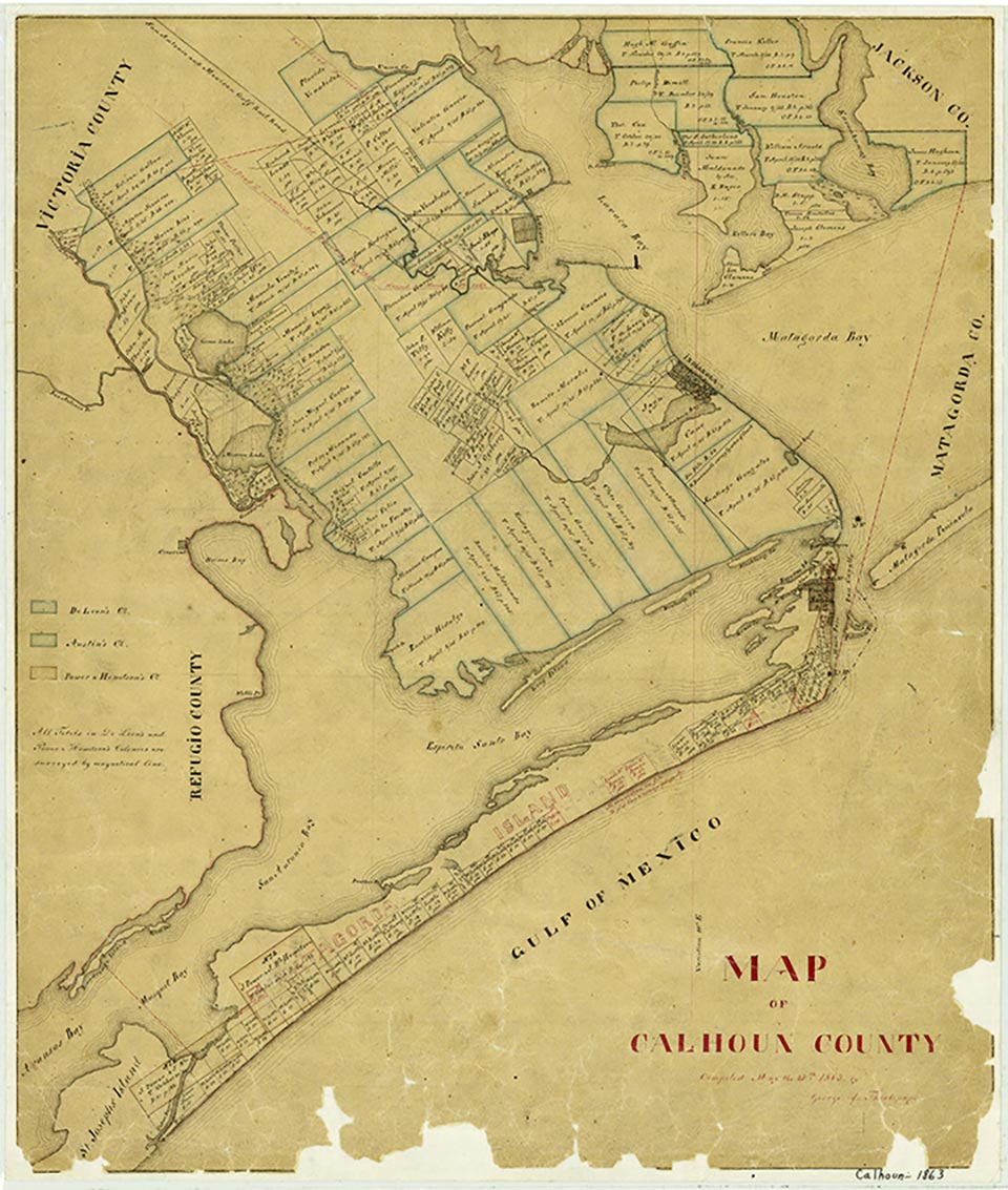
Port Lavaca, originally known as Lavaca, the county seat of Calhoun County, is in the north central part of the county (at 28°37' N, 96°38' W) on the west coast of Lavaca Bay. The town is served by U.S. Highway 87, State highways 35 and 238, Farm roads 1090 and 3084, and the Southern Pacific line. Lynn Bayou drains the northern part of the town and flows into the municipal harbor. Little Chocolate Bayou flows about a mile west of town and empties into Chocolate Bay, about a mile south of Port Lavaca. The town was founded in the aftermath of the Linnville raid of 1840, a Comanche attack that swept through Victoria, about twenty-five miles to the northwest, and Linnville, 3½ miles to the northeast. The burning of Linnville prompted many of its citizens to move to the site of what is now Port Lavaca. Thomas McConnell, who lost his Victoria home during the raid, purchased land for the town from Isidro Benavides of De Leon's colony. The town was named La Vaca ("the cow") in 1841 and was laid out by 1842. It was situated on a bluff some fifteen to twenty feet above the bay. Commission men from the East reportedly played a significant role in establishing Lavaca, which they envisioned as an important shipping point for exporting raw materials and importing manufactured goods. Lavaca fulfilled this expectation, succeeding Linnville as the busiest port on the adjoining Matagorda and Lavaca bays during the period of the Republic of Texas.
When Calhoun County was established in 1846, Lavaca became the county seat. It also received a post office. In 1847 the community became a terminus for ships of the Morgan lines, and in November of that year a stagecoach route was established between Lavaca and Victoria. In 1849 Lavaca raised its docking fees to help pay for improvements to its wharves. Soon afterward Charles Morgan abandoned Lavaca and rerouted his ships to the mouth of Powderhorn Bayou, a few miles south of Indianola. The presence of sandbars in Lavaca Bay, which forced Morgan's ships to dock at a distance and to employ costly and time-consuming lighters, may also have prompted the move. Despite the loss of the Morgan-lines trade, Lavaca continued to prosper and to compete for supremacy as the premier port in the Matagorda Bay region. Wagontrains and carts freighted goods between Lavaca and southern and western Texas and northern Mexico. Export items included cattle, hides, tallow, and horns, as well as cotton, wool, pecans, and mustang grape wine; also exported were copper, lead, silver, and gold. In 1850 Lavaca had a free population of 231 and a slave population of 84. Of the 231 free individuals, only 28 were foreign born. (Indianola, an entry port for the Adelsverein, had a free population of 378, of whom 237 were foreign born.) That same year Lavaca had two schools for girls, with a combined enrollment of seventy, and one school for boys, with an enrollment of thirty-six. The San Antonio and Mexican Gulf Railroad was chartered on September 5, 1850. Grading on the road began in 1856, and in 1858 five miles of track were put into operation. Though this short stretch of road ended at the time in empty prairie, the company did a healthy business. In 1861, twenty-three additional miles were completed into Victoria. In 1852 Indianola became the county seat, as it had the advantage over Lavaca of a deepwater port at nearby Powderhorn. That year Lavaca businessmen invested in dredging equipment to dig a channel through the sandbars that obstructed access to their port. In 1854 Lavaca had a district school. Newspapers during this early period included the Lavaca Journal (1847-ca. 1848); the Commercial (1850–53); the Lavaca Express, which published one issue in 1853 before moving to Goliad; the Lavaca Register (1854-ca. 1855); and the Lavaca Herald (1855–59), which was succeeded in 1860 by the Gulf Key.
Lonnie Ficklen Maywald | © TSHA
Adapted from the official Handbook of Texas, a state encyclopedia developed by Texas State Historical Association (TSHA). It is an authoritative source of trusted historical records.
- ✅ Adoption Status:
- This place is available for adoption! Available for adoption!
- Adopted by:
- Your name goes here
- Dedication Message:
- Your message goes here
Belongs to
Port Lavaca is part of or belongs to the following places:
Currently Exists
Yes
Place type
Port Lavaca is classified as a Town
Associated Names
- [-Labaca]
- [-Labbacca]
- [Lavaca]
Location
Latitude: 28.61971830Longitude: -96.62772000
Has Post Office
Yes
Is Incorporated
Yes
Population Count, 2021 View more »
11,259