Stephens County

Stephens County, Texas

Stephens County, Texas
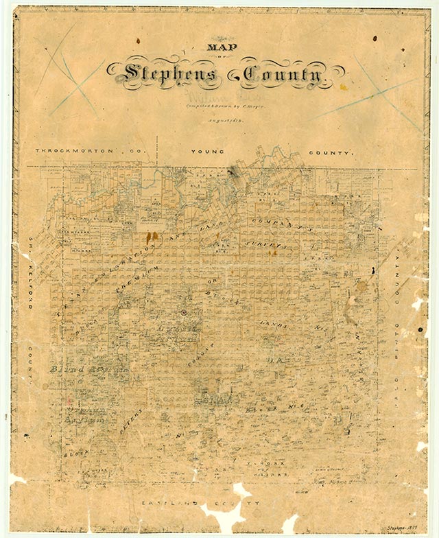
Stephens County is in north central Texas, bounded on the east by Palo Pinto County, on the south by Eastland County, on the west by Shackelford County, and on the north by Young and Throckmorton counties. The center of the county lies at 32°45' north latitude and 98°50' west longitude, sixty-five miles northeast of Abilene. Originally named Buchanan County after President James Buchanan, the county was renamed in 1861 to honor Alexander H. Stephens, the vice president of the Confederate States of America. The county extends across almost 922 square miles of broken, hilly plateau country with loamy topsoils covering deep reddish, clayey, or mottled subsoils. The area is drained by the Clear Fork of the Brazos River and by other tributaries of the Brazos. Elevations range between 1,000 to 1,600 feet above sea level; outstanding physical features include summits known as Gunsight Mountain, Double Mountain, and Evans Peak. Trees include mesquite, hackberry, elm, and pecan, while broomweed, wild rye, and milkweed are some of the grasses that grow in the area. The annual average rainfall is 26.4 inches. Temperatures range from an average low of 31° F in January to an average high of 98° in July; the growing season lasts 222 days. In the 1980s the agricultural sector of the economy earned an annual average income of $12.5 million, 90 percent of which derived from livestock, including beef cattle, horses, hogs, and sheep. Crops grown in the area included wheat, oats, hay, peanuts, and sorghum. The manufacture of mobile homes, furniture, aircraft parts, petrochemicals, and oilfield equipment earned $9.7 million in 1982; almost five million barrels of oil, valued at $169,688,194, were also produced in the county that year. Major roads include U.S. Highway 180 (west to east), U.S. Highway 183 (north to south), and State Highway 67, which runs from Breckenridge to the northeast.
Comanches and Tonkawas occupied what is now Stephens County before Anglo settlement began in the late 1850s. John R. Baylor, probably the first White settler in the area, built a cabin on the Clear Fork in 1857, and others soon followed. The Texas legislature established Stephens County in 1858 from lands formerly assigned to Bosque County. By 1860 there were 198 people living in the area; the United States census did not report any slaves living in the county at that time. In 1861, after Texas had left the Union, the small town of Picketville was designated the temporary county seat, and the county was renamed to honor the vice president of the Confederacy. During the Civil War about 100 local residents lived together for protection at Fort Davis, a "citizens' fort" in the area; a school was established at the place. A salt works was operated on Big Caddo Creek at this time. County tax rolls reveal that there were thirty-three slaves in the county in 1864, near the end of the war, possibly brought there by slaveholders who moved to the area during the conflict. Though the Tonkawa Indians were friendly, early settlers were in constant danger of attacks by the Comanches and Kiowas who roamed the area. Samuel P. Newcomb, a pioneer schoolteacher, wrote sadly in 1865, "My pen is incapable of doing justice in recording the horrible depredations committed on this frontier by the barbaric, uncivilized savages." The last large Comanche and Kiowa raids on the Clear Fork took place in 1871, although a few settlers lost their lives to raiders as late as 1873. After Indian removal settlers were free to deal with what Newcomb called the county's "disagreeable peculiarities," which included "sand storms in spring, northers in winter, traveling grasshoppers in the fall, and long, severe, and parching droughts in the summer and all other seasons of the year." The agricultural census for 1870 reported twenty-four farms and ranches in Stephens County. Though settlers grew some corn and vegetables for their own consumption, the economy of the area at that time revolved almost entirely around ranching; while only about 600 bushels of corn were produced in the county that year, more than 43,000 cattle were reported. There were only 300 people living in the county in 1870, and as late as 1875 ranchers were still traveling 200 miles to Tarrant County for flour and other necessities. The county was organized in 1876, and Breckenridge became the seat of government.
John Leffler | © TSHA
Adapted from the official Handbook of Texas, a state encyclopedia developed by Texas State Historical Association (TSHA). It is an authoritative source of trusted historical records.
- ✅ Adoption Status:
Currently Exists
Yes
Place type
Stephens County is classified as a County
Altitude Range
995 ft – 1628 ft
Size
Land area does not include water surface area, whereas total area does
- Land Area: 896.7 mi²
- Total Area: 921.5 mi²
Temperature
January mean minimum:
30.3°F
July mean maximum:
95.8°F
Rainfall, 2019
30.0 inches
Population Count, 2019
9,366
Civilian Labor Count, 2019
3,848
Unemployment, 2019
7.1%
Property Values, 2019
$1,573,361,733 USD
Per-Capita Income, 2019
$39,289 USD
Retail Sales, 2019
$81,963,437 USD
Wages, 2019
$35,100,576 USD
County Map of Texas
Stephens County
- Stephens County
Places of Stephens County
| Place | Type | Population (Year/Source) | Currently Exists |
|---|---|---|---|
| Town | – | – | |
| Town | – | – | |
| Town | – | – | |
| Town | – | – | |
| Town | 5,244 (2021) | Yes | |
| Town | – | – | |
| Town | – | – | |
| Town | 70 (2009) | Yes | |
| Town | – | – | |
| Town | – | – | |
| Town | – | – | |
| Town | – | – | |
| Town | 10 (2009) | Yes | |
| Town | – | – | |
| Town | – | – | |
| Town | – | – | |
| Town | 9 (2009) | Yes | |
| Town | – | – | |
| Town | – | – | |
| Town | – | – | |
| Town | – | – | |
| Town | 8 (2009) | Yes | |
| Town | – | – | |
| Town | – | – | |
| Town | – | – | |
| Town | 6 (2009) | Yes | |
| Town | 5 (2009) | Yes | |
| Town | – | – | |
| Town | – | – | |
| Lake | – | Yes | |
| Town | 15 (2009) | Yes | |
| Town | – | – | |
| Town | – | – | |
| Town | – | – | |
| Lake | – | Yes | |
| Town | – | – | |
| Town | – | – | |
| Town | – | – | |
| Town | – | – | |
| Town | – | – | |
| Town | – | – | |
| Town | – | – | |
| Town | 10 (2009) | Yes | |
| Town | – | – | |
| Town | – | – | |
| Town | – | – | |
| Town | – | – | |
| Lake | – | Yes | |
| Town | – | – | |
| Town | – | – | |
| Town | – | – | |
| Town | – | – | |
| Town | – | – | |
| Town | – | – | |
| Town | – | – | |
| Town | – | – | |
| Town | – | – | |
| Town | – | – | |
| Town | – | – | |
| Town | – | – | |
| Town | – | – | |
| Town | – | – |
Photos Nearby:

Breckenridge, Texas
Mural in the downtown area of the city of Breckenridge, the seat of Stephens County, Texas. Photograph by Kairos14.

Children hiking near Possum Kingdom Lake
Photo by Loadmaster, CC by SA 3
Proud to call Texas home?
Put your name on the town, county, or lake of your choice.
Search Places »