Walker County

Walker County, Texas

Walker County, Texas
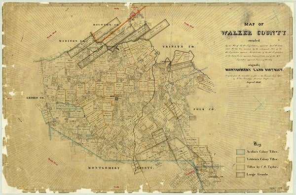
Walker County is in southeast Texas. The center of the county is at 30°47' north latitude and 95°33' west longitude. Huntsville, the county seat, is near the center of the county sixty miles north of Houston. The area was originally named for Robert J. Walker of Mississippi, who introduced into the United States Congress the resolution for the annexation of Texas; because he was a Unionist during the Civil War, however, in 1863 the state legislature changed the honoree to Samuel H. Walker. Walker County encompasses 801 square miles of rolling hills and open prairies in the Piney Woods vegetation area; around 70 percent of the county is blanketed by forests of loblolly, short-leaf and long-leaf pine, and hardwoods. The area rests at the extreme western end of the Coastal Plain region. Elevations in the county range from 140 to 404 feet above sea level. The land is well watered, receiving forty-six inches of rain each year, and is drained by two major rivers, the Trinity River in the north and the San Jacinto River in the south. Numerous creeks also cross the county. Bedias Creek forms part of the northwestern boundary and empties into the Trinity River, as do Harmon, Carolina, and Nelson creeks. Mill, East and West Sandy, and Robinson creeks drain into the San Jacinto River in the south. Forest soils are typically sands and clays, but alluvial loams are found in creek beds and at lower elevations. Temperatures range from an average low of 38° F in January to an average high of 95° F in July; the growing season lasts 265 days. Clay deposits-ceramic and brick clays and Fuller's earth-have been mined commercially, as have other minerals, including sand, gravel, lignite, volcanic ash, and petroleum. Walker County is crossed by the Union Pacific Railroad and Interstate Highway 45. Transportation in the area is also facilitated by a series of farm-to-market roads radiating outward from Huntsville.
The Cenis Indians were among the earliest known residents of the area that is now Walker County. They lived between the Trinity and the San Jacinto rivers, where they raised corn crops which they traded with western Indians for horses, hides, and Spanish goods. The Cenis were wiped out in 1780 by invading tribes that had been driven from their own ancestral homes along the Mississippi River by American expansion. Another band of Indians, the Bidais, inhabited the northern area of present Walker County and eked out a marginal existence as hunter-gatherers. The Huntsville area, situated at the edge of the southern forest, became an important site for intertribal trade. Here the Alabama-Coushatta, the Neches, and the Nacogdoches tribes from the forests to the south arrived to swap goods with the Comanches, Lipans, and Tonkawas of the plains. The first Europeans to explore the area may have been Spaniards under the leadership of Luis de Moscoso Alvarado, who arrived in the region in 1542. Frenchman René Robert Cavelier, Sieur de La Salle crossed the area in 1687. To counter the French threat presented by the La Salle expedition, a military company captained by Alonso De León was dispatched to East Texas in 1689 by the Viceroy of New Spain. De León's men cleared a lane that became La Bahía Road. A portion of this thoroughfare passed over the area of present-day Walker County. In the early 1830s colonists from the United States arrived in the area. Pleasant Gray and his brother Ephraim established a trading post on the site that eventually became Huntsville, named after Huntsville, Alabama, Pleasant's former home. In the mid-1830s the brothers conducted a lucrative trade with the neighboring Indians.
John Leffler | © TSHA
Adapted from the official Handbook of Texas, a state encyclopedia developed by Texas State Historical Association (TSHA). It is an authoritative source of trusted historical records.
- ✅ Adoption Status:
- This place is available for adoption! Available for adoption!
- Adopted by:
- Your name goes here
- Dedication Message:
- Your message goes here
Currently Exists
Yes
Place type
Walker County is classified as a County
Altitude Range
131 ft – 500 ft
Size
Land area does not include water surface area, whereas total area does
- Land Area: 784.2 mi²
- Total Area: 801.5 mi²
Temperature
January mean minimum:
39.7°F
July mean maximum:
93.3°F
Rainfall, 2019
49.1 inches
Population Count, 2019
72,971
Civilian Labor Count, 2019
23,362
Unemployment, 2019
8.0%
Property Values, 2019
$5,259,333,965 USD
Per-Capita Income, 2019
$28,016 USD
Retail Sales, 2019
$862,795,908 USD
Wages, 2019
$277,354,695 USD
County Map of Texas
Walker County
- Walker County
Places of Walker County
| Place | Type | Population (Year/Source) | Currently Exists |
|---|---|---|---|
| Town | – | – | |
| Town | – | – | |
| Town | – | – | |
| Town | – | – | |
| Town | – | – | |
| Town | – | – | |
| Town | – | – | |
| Town | – | – | |
| Town | – | – | |
| Town | – | – | |
| Town | – | – | |
| Town | – | – | |
| Town | – | – | |
| Town | – | – | |
| Town | – | – | |
| Town | – | – | |
| Town | – | – | |
| Town | 240 (2009) | Yes | |
| Town | – | – | |
| Town | 150 (2009) | Yes | |
| Town | – | – | |
| Town | – | – | |
| Town | – | – | |
| Town | – | – | |
| Town | – | – | |
| Town | – | – | |
| Town | – | – | |
| Town | – | – | |
| Town | – | – | |
| Town | – | – | |
| Town | – | – | |
| Town | – | – | |
| Town | – | – | |
| Town | – | – | |
| Town | 250 (2009) | Yes | |
| Town | – | – | |
| Town | – | – | |
| Town | – | – | |
| Town | 100 (2009) | Yes | |
| Town | – | – | |
| Town | – | – | |
| Town | – | – | |
| Town | – | – | |
| Town | – | – | |
| Town | 46,288 (2021) | Yes | |
| Town | – | – | |
| Town | – | – | |
| Town | – | – | |
| Town | – | – | |
| Town | – | – | |
| Town | – | – | |
| Town | 126 (2009) | Yes | |
| Lake | – | Yes | |
| Lake | – | Yes | |
| Town | – | – | |
| Town | – | – | |
| Town | – | – | |
| Town | – | – | |
| Town | – | – | |
| Town | – | – | |
| Town | – | – | |
| Town | – | – | |
| Town | – | – | |
| Town | – | – | |
| Town | 966 (2021) | Yes | |
| Town | – | – | |
| Town | – | – | |
| Town | – | – | |
| Town | – | – | |
| Town | – | – | |
| Town | – | – | |
| Town | 98 (2009) | Yes | |
| Town | – | – | |
| Town | 450 (2009) | Yes | |
| Town | – | – | |
| Town | – | – | |
| Town | – | – | |
| Town | – | – | |
| Town | 553 (2021) | Yes | |
| Town | – | – | |
| Town | – | – | |
| Town | – | – | |
| Town | – | – | |
| Town | – | – | |
| Town | – | – | |
| Town | – | – | |
| Town | – | – | |
| Town | – | – | |
| Town | – | – | |
| Town | – | – | |
| Town | – | – | |
| Town | – | – | |
| Town | – | – | |
| Town | 25 (2009) | Yes | |
| Town | – | – | |
| Town | – | – | |
| Town | – | – | |
| Town | – | – | |
| Town | – | – |
Photos Nearby:

Huntsville, Texas.
Welcom Sign in Huntsville, the seat of Walker County, Texas. Photograph by WhisperToMe.

A beautiful morning on Lake Conroe
Photo by Katie Hougland Bowen, Flickr, CC2

Proud to call Texas home?
Put your name on the town, county, or lake of your choice.
Search Places »