Waller County

Waller County, Texas

Waller County, Texas
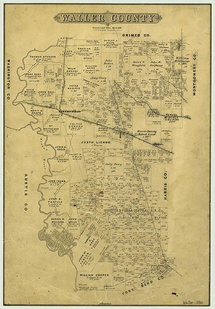
Waller County is in the lower coastal plain of southeast Texas. The center of the county lies at 29°11' north latitude and 96° 01' west longitude. Hempstead, the county's seat of government and largest city, is twenty-five miles northwest of Houston. The county covers 514 square miles of land, from the rolling timbered area in the northern part of the county to the coastal prairie in the south, where marsh and bunch grasses grow. Elevations range between 100 and 300 feet above sea level. Soil types vary from the fertile alluvial soil in the Brazos river bottoms to the sandy loam soil in the prairie region and the black waxy soils in the small southern area of the county. The Brazos River defines the county's western boundary and is the area's most important stream, but the county is also crossed by a number of creeks, including Clear, Spring, Walnut, Brushy, Pond, Birch, Mound, Besser, Iron, and Cedar creeks; Hubbard Springs provides mineral waters. Small lakes in the area include Garrett Lake, Mound Lake, and Hannay Lake. Pine trees predominate in northeastern Waller County, while pecan trees are found on the Brazos river bottom, and live oak, sycamore, ash, elm, cottonwood, walnut trees, and wild fruits and berries are found elsewhere. Temperatures range from an average low of 41° F in January to an average high of 95° in July. The average annual precipitation is forty-two inches, and the average growing season lasts 288 days. The economy of Waller County revolves primarily around farming, cattle, and forest products. Mineral resources include oil and gas, salt domes, shell, gypsum, sulphur, sand, gravel, and brick clay. Waller County is served by U.S. Highway 290, State Highway 6, the Union Pacific Railroad, and three airports.
Before settlement large herds of mustangs and wild cattle roamed through what is now Waller County; deer and prairie chickens were also abundant. The Bidai Indians lived a migratory life in the area, where they engaged in hunting and fishing. By the time of Anglo occupation, this group had been reduced to only about 100 members. European explorers apparently did not enter the area before the 1800s. The area that is now Waller County was originally part of the Municipality of Washington under Mexican rule, then became part of Washington County and then Austin County. The area began to be settled in the early 1820s as part of Stephen F. Austin's original colony. In 1821 Jared Groce moved from Alabama with 100 slaves and established Bernardo Plantation, four miles from the site of present Hempstead. Groce grew a crop of cotton in 1822 (perhaps the first in Texas), and in 1825 he constructed the first cotton gin in Texas. A blacksmith shop and commissary were also established at Bernardo, and the plantation became the nucleus of settlement in the area. In April 1836, during the Texas Revolution, Sam Houston's army briefly camped at the plantation. Other early settlers on the east bank of the Brazos were Isaac M. Pennington, first schoolteacher in Austin's colony, and two free Blacks, Lewis B. Jones and Samuel Hardin. The southern part of what became Waller County developed more slowly than the northern sections did. James Pattison established a plantation close to the site of present-day Pattison, and Edwin Waller settled near the site of the present community of Clemons sometime after 1840. Most settlers in the area came from the southern United States. By 1845 the east bank of the Brazos had become a prosperous, cotton-exporting plantation area; about 200 Whites owned more than 1,000 slaves. Jared Groce's son, Leonard W. Groce, acquired some of his father's land in 1854 and built Liendo Plantation, which became the area's social center. During these years most of the area's cotton crop was taken to Houston for marketing. Planters had to rely on inadequate steamboat and poor road transportation until the late 1850s, but development of the area was accelerated in 1858, when the Houston and Texas Central Railway built into the county. Hempstead, a new town located at the railroad's terminus in the northwestern part of the county, was incorporated in November 1858 and soon became a major trade center for the area, as cotton and other agricultural exports were increasingly shipped down the railroad to the coast. Hempstead's importance as a trade center grew in 1861, when the Washington County Rail Road connected the town to Brenham. The formation of Hempstead caused a shift in the county's population, as people moved away from the northern village of Rock Island, which earlier had been the only community in the region.
Carole E. Christian, John Leffler | © TSHA
Adapted from the official Handbook of Texas, a state encyclopedia developed by Texas State Historical Association (TSHA). It is an authoritative source of trusted historical records.
- ✅ Adoption Status:
- This place is available for adoption! Available for adoption!
- Adopted by:
- Your name goes here
- Dedication Message:
- Your message goes here
Currently Exists
Yes
Place type
Waller County is classified as a County
Altitude Range
100 ft – 350 ft
Size
Land area does not include water surface area, whereas total area does
- Land Area: 513.4 mi²
- Total Area: 517.8 mi²
Temperature
January mean minimum:
38.0°F
July mean maximum:
95.0°F
Rainfall, 2019
45.5 inches
Population Count, 2019
55,246
Civilian Labor Count, 2019
22,966
Unemployment, 2019
8.8%
Property Values, 2019
$8,049,855,781 USD
Per-Capita Income, 2019
$39,995 USD
Retail Sales, 2019
$595,343,606 USD
Wages, 2019
$252,679,638 USD
County Map of Texas
Waller County
- Waller County
Places of Waller County
| Place | Type | Population (Year/Source) | Currently Exists |
|---|---|---|---|
| Town | – | – | |
| Town | – | – | |
| Town | – | – | |
| Town | – | – | |
| Town | 5,501 (2021) | Yes | |
| Town | – | – | |
| Town | – | – | |
| Town | – | – | |
| Town | – | – | |
| Town | – | – | |
| Town | – | – | |
| Town | – | – | |
| Town | – | – | |
| Town | 150 (2009) | Yes | |
| Town | 500 (2009) | Yes | |
| Town | – | – | |
| Town | – | – | |
| Town | – | – | |
| Town | 100 (2009) | Yes | |
| Town | 6,028 (2021) | Yes | |
| Town | – | – | |
| Town | – | – | |
| Town | – | – | |
| Town | – | – | |
| Town | – | – | |
| Town | – | – | |
| Town | 24,005 (2021) | Yes | |
| Town | – | – | |
| Town | – | – | |
| Town | – | – | |
| Town | – | – | |
| Town | – | – | |
| Town | – | – | |
| Town | – | – | |
| Town | – | – | |
| Town | – | – | |
| Town | 180 (2009) | Yes | |
| Town | 594 (2021) | Yes | |
| Town | – | – | |
| Town | – | – | |
| Town | – | – | |
| Town | 1,161 (2021) | Yes | |
| Town | – | – | |
| Town | – | – | |
| Town | 6,843 (2021) | Yes | |
| Town | – | – | |
| Town | – | – | |
| Town | – | – | |
| Town | – | – | |
| Town | – | – | |
| Town | – | – | |
| Town | – | – | |
| Town | – | – | |
| Town | – | – | |
| Town | 250 (2009) | Yes | |
| Town | – | – | |
| Town | 2,796 (2021) | Yes | |
| Town | – | – | |
| Town | – | – |
Proud to call Texas home?
Put your name on the town, county, or lake of your choice.
Search Places »