Willacy County

Willacy County, Texas

Willacy County, Texas
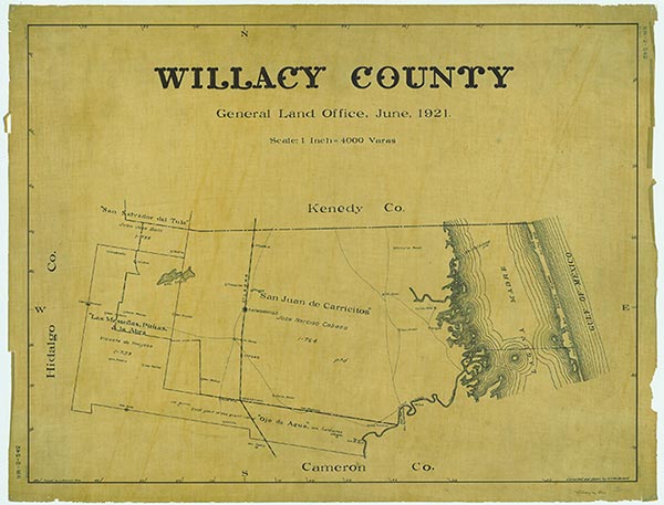
Willacy County, in the Rio Grande valley of South Texas, is thirty miles north of Mexico; it is bordered by Kenedy, Hidalgo, and Cameron counties and the Gulf of Mexico. The county was the 253rd county to be formed and was named for state senator John G. Willacy. Raymondville, the county's largest town and county seat, is in the north central part of the county on U.S. Highway 77 and the Missouri Pacific Railroad. The center of the county is at 26°27' north latitude and 97°40' west longitude. Other communities in the county are the incorporated towns of Lyford and San Perlita and the unincorporated towns of Lasara, Los Coyotes, Porfirio, Port Mansfield, Santa Monica, Sebastian, and Willamar. Willacy County comprises 589 square miles with an elevation ranging from sea level to fifty feet. The nearly level to undulating terrain of the South Texas Plains is surfaced by dark brown to red loam, over deep, clayey subsoils; the flora includes mesquite, grasses, thorny shrubs, and cacti. Along the Gulf Coast the soils are sandy and saline or cracking and support cordgrasses, seashore saltgrass, and marsh millet. Natural resources included caliche, oil, and gas. The climate is subtropical-humid; tropical storms and hurricanes are possible from June through October. Temperatures range from an average low of 48° F to a high of 69° in January and from 74° to 95° in July. Rainfall averages twenty-seven inches a year, and the growing season lasts for 318 days.
Nomadic Coahuiltecan Indians inhabited the region for 11,000 years. The Karankawa Indians lived along the coast. Willacy County is in the area of Texas first known to White men. In 1519 the coast was mapped and named Amichel by Alonzo Álvarez de Pineda. In the 1530s it was crossed by Álvar Núñez Cabeza de Vaca. In 1554 a fleet of twenty ships was wrecked on South Padre Island, which is within the borders of Willacy County (see PADRE ISLAND SPANISH SHIPWRECKS OF 1554). The area of the county was under the jurisdiction of Nuevo Santander, and a survey was made as early as July 1790. Extant records show that three land grants were made in the Willacy County area by the Spanish and Mexican governments. The earliest Spanish land grant was El Agostadero de San Juan Carricitos, made to José Narciso Cabazos on February 22, 1792. Cabazos immediately settled the land and stocked his ranch with 900 cattle; his grant contained more than a half million acres and included much of the area of future Willacy County and parts of Hidalgo and Kenedy counties. Two other land grants in the Willacy County area were made to Vicente de Ynojosa by Spain in 1798. At the time a salt lake known as La Sal Vieja supplied all of the area of what is now South Texas and northern Mexico with salt. When Cabazos died he left his property to his heirs, who kept the land under their control until about 1811, when hostile Indians drove them off. Indians were a problem for those grantees farthest away from the river. In 1821 a trade road was built from Matamoros through the future Willacy County to San Patricio. The county area fell within the territory between the Rio Grande and Nueces River, disputed after the Texas Revolution. Gen. Zachary Taylor crossed the Arroyo Colorado at Paso Real when he was in the area during the Mexican War. The route he took to cross the lower Rio Grande valley became known as "General Taylor's Road" to area residents. This road and the Old San Antonio Road west of La Sal Vieja were the only routes overland into the lower Rio Grande valley. During the Civil War Paso Real became an important crossing point for Confederate cotton exports. When federal coastal blockades cut off imports and exports for the entire South, this road moved cotton down to Matamoros, where it was exchanged for guns, ammunition, medicines, cloth, shoes, blankets, and other vital goods. When Philip H. Sheridan reached the area with his cavalry in May 1865, he quipped, "If I possessed both Texas and Hell, I'd rent out Texas and live in Hell."
Alicia A. Garza | © TSHA
Adapted from the official Handbook of Texas, a state encyclopedia developed by Texas State Historical Association (TSHA). It is an authoritative source of trusted historical records.
- ✅ Adoption Status:
Currently Exists
Yes
Place type
Willacy County is classified as a County
Altitude Range
0 ft – 94 ft
Size
Land area does not include water surface area, whereas total area does
- Land Area: 590.6 mi²
- Total Area: 784.3 mi²
Temperature
January mean minimum:
47.6°F
July mean maximum:
96.7°F
Rainfall, 2019
26.1 inches
Population Count, 2019
21,358
Civilian Labor Count, 2019
6,602
Unemployment, 2019
13.0%
Property Values, 2019
$1,983,990,494 USD
Per-Capita Income, 2019
$28,593 USD
Retail Sales, 2019
$85,120,499 USD
Wages, 2019
$38,065,211 USD
County Map of Texas
Willacy County
- Willacy County
Places of Willacy County
| Place | Type | Population (Year/Source) | Currently Exists |
|---|---|---|---|
| Town | – | – | |
| Town | 0 (2012) | – | |
| Town | – | – | |
| Town | – | – | |
| Town | 857 (2021) | Yes | |
| Town | 366 (2021) | Yes | |
| Town | – | – | |
| Town | 2,210 (2021) | Yes | |
| Town | – | – | |
| Town | – | – | |
| Town | – | – | |
| Town | – | – | |
| Town | – | – | |
| Town | – | – | |
| Town | 132 (2021) | Yes | |
| Town | 175 (2021) | Yes | |
| Town | 10,510 (2021) | Yes | |
| Town | – | – | |
| Town | – | – | |
| Town | 531 (2021) | Yes | |
| Town | – | – | |
| Town | 10 (2021) | Yes | |
| Town | 1,331 (2021) | Yes | |
| Town | – | – | |
| Town | 10 (2017) | – | |
| Town | – | – | |
| Town | 225 (2021) | Yes |
Proud to call Texas home?
Put your name on the town, county, or lake of your choice.
Search Places »