Young County
.jpg "Young County, Texas")
.jpg)
Young County, Texas

Young County, Texas
Young County is in north central Texas. The center of the county is at 33°10' north latitude and 98°40' west longitude, fifty-five miles south of Wichita Falls. Graham, the county's seat of government, is in the southeastern section of the county, sixty-five air miles northwest of Fort Worth. The county was named for Col. William C. Young. It covers 919 square miles of hilly, broken country with elevations from 1,000 to 1,300 feet above sea level. The area is drained by Lake Graham, near the center of the county, and by the Brazos River, which forms Possum Kingdom Lake in the southeastern part of the county. Young County is in the Cross Timbers and Prairie vegetation areas, covered by tall and mid grasses, live oak and post oak, and juniper and mesquite. The climate is subtropical subhumid, with an average minimum temperature of 31° F in January and an average maximum of 98° in July; the average annual rainfall is twenty-eight inches. The growing season lasts 216 days. The area is served by U.S. Highway 380 and State highways 16 and 79.
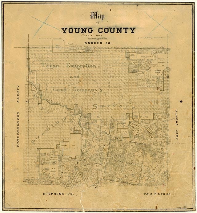
Spanish explorers Diego Ortiz Parrilla and Pedro Vial were the first to call attention to the area. In 1759 Parrilla crossed the northwest corner of what is now Young County en route to the Taovaya Indian Village on Red River, and in 1789 Vial followed the Brazos River through the region while returning to Santa Fe from San Antonio. The county was included in the Peters colony, a Mexican land grant made in 1841. Though the settlement terms of the grant were loosely fulfilled eventually by the Texas Emigration and Land Company, the Young County portion of the grant remained unsettled until the 1850s. In 1851 the United States Army established Fort Belknap on the Red Fork of the Brazos, where eventually the town of Belknap grew up. Fort Belknap became one of the largest and most important military posts in North Texas prior to the Civil War. In 1854 the Brazos Indian Reservation was surveyed by Capt. Randolph B. Marcy twelve miles southeast of the fort. The first settlers in the area included John and Will Peveler, contractors who supplied the fort and the reservation. Young County was established by the Texas legislature in 1856 from lands formerly assigned to Bosque and Fannin counties and was attached to Wise County for judicial purposes until it was organized later that same year. The town of Belknap was chosen as the county seat and was a stop on the Butterfield Overland Mail route from 1858 to 1861. The county's early years were marred by conflicts between Indians and White settlers in the region. The Brazos Reservation, originally 18,576 acres, was doubled in size to make room for other western Indian tribes. Among the 2,000 Indians living there were Caddos, Anadarkos, Wacos, and Tonkawas, each with their own villages and all relieved to have protection from the Comanches. They cultivated 600 acres in wheat, vegetables, and melons under agriculturist J. J. Strum. Some Indians served as scouts for the army and Texas Rangers against warring tribes. Neighboring Whites objected to Indians' military duties and blamed any depredations on reservation Indians, even when the culprits could have been other, unsettled tribes. Racial antagonisms, fueled by the Whiteman, a Jacksboro newspaper, brought tensions to a state of armed belligerency by 1858. Governor Hardin R. Runnels and Gen. Sam Houston asked the federal government to move the reservation Indians from Texas. After eight Indians who had been given permission to hunt in Palo Pinto were killed in their sleep by Whites, federal troops fortified a reservation building to protect Indian women and children against attack; on January 9, 1859, Governor Runnels warned citizens against attacking Indians. Nevertheless, John R. Baylor led a force to one reservation on May 23, 1859, and killed an Indian woman and an old man. Indians struck back in a battle just off the reservation that cost casualties to both sides. The Indians were removed to Indian Territory in July. Some months later most were slaughtered by Comanches.
John Leffler | © TSHA
Adapted from the official Handbook of Texas, a state encyclopedia developed by Texas State Historical Association (TSHA). It is an authoritative source of trusted historical records.
- ✅ Adoption Status:
Currently Exists
Yes
Place type
Young County is classified as a County
Pronunciations
- yuhng
Altitude Range
995 ft – 1522 ft
Size
Land area does not include water surface area, whereas total area does
- Land Area: 914.5 mi²
- Total Area: 930.9 mi²
Temperature
January mean minimum:
28.3°F
July mean maximum:
96.2°F
Rainfall, 2019
31.5 inches
Population Count, 2019
18,010
Civilian Labor Count, 2019
7,644
Unemployment, 2019
6.1%
Property Values, 2019
$1,995,597,201 USD
Per-Capita Income, 2019
$50,231 USD
Retail Sales, 2019
$287,489,250 USD
Wages, 2019
$77,843,369 USD
County Map of Texas
Young County
- Young County
Places of Young County
| Place | Type | Population (Year/Source) | Currently Exists |
|---|---|---|---|
| Town | – | – | |
| Town | – | – | |
| Town | – | – | |
| Town | – | – | |
| Town | – | – | |
| Town | 24 (2014) | Yes | |
| Town | – | – | |
| Town | – | – | |
| Town | – | – | |
| Town | – | – | |
| Town | – | – | |
| Town | – | – | |
| Town | – | – | |
| Town | – | – | |
| Town | – | – | |
| Town | – | – | |
| Town | 100 (2014) | Yes | |
| Town | – | – | |
| Town | – | – | |
| Town | – | – | |
| Town | – | – | |
| Town | 8,765 (2021) | Yes | |
| Town | – | – | |
| Town | – | – | |
| Town | – | – | |
| Town | – | – | |
| Town | – | – | |
| Town | – | – | |
| Town | 110 (2014) | Yes | |
| Town | – | – | |
| Lake | – | Yes | |
| Town | – | – | |
| Town | – | – | |
| Town | 95 (2021) | Yes | |
| Town | – | – | |
| Town | 25 (2014) | Yes | |
| Town | – | – | |
| Town | – | – | |
| Town | 29 (2014) | Yes | |
| Town | 531 (2021) | Yes | |
| Town | – | – | |
| Town | 3,019 (2021) | Yes | |
| Town | – | – | |
| Town | 18 (2014) | Yes | |
| Town | – | – | |
| Town | – | – | |
| Lake | – | Yes | |
| Town | – | – | |
| Town | – | – | |
| Town | – | – | |
| Town | – | – | |
| Town | – | – | |
| Town | – | – | |
| Town | – | – | |
| Town | 100 (2014) | Yes | |
| Town | – | – | |
| Town | – | – | |
| Town | – | – | |
| Town | – | – | |
| Town | – | – | |
| Town | – | – | |
| Town | – | – |
Photos Nearby:

Graham, Texas
View of the old City Hall in the City of Graham, seat of Young County, Texas. Photograph by Renelibrary.

Children hiking near Possum Kingdom Lake
Photo by Loadmaster, CC by SA 3
Proud to call Texas home?
Put your name on the town, county, or lake of your choice.
Search Places »