San Saba County

San Saba County, Texas

San Saba County, Texas
San Saba County is in Central Texas in the Llano Basin region. Its largest city and county seat, San Saba, is ninety miles northwest of Austin and 110 miles southwest of Waco. The geographic center of the county is at 31°10' north latitude and 99°41' west longitude. San Saba County covers 1,136 square miles and has an elevation of 1,100 to 1,800 feet. Mineral resources include dolomite, limestone, natural gas, and industrial sand and gravel. North of the San Saba River the terrain varies from steep to rolling. South of the river it varies from flat with deep local dissection to slightly hilly. Soil is composed of shallow, stony clays and sandy loam; vegetation consists primarily of oak, mesquite, and cedar, with occasional cacti and bluestem and gramma grasses. Pecan trees are also found in abundance along the Colorado and San Saba rivers. Primary streams include Richland, Wallace, Simpson, Rough, Wilbarger, Brady, and Cherokee creeks. Indigenous wildlife includes deer, javelinas, coyotes, bobcats, and turkeys. The temperature ranges from an average low of 34° F in January to an average high of 96° in July. Rainfall averages 26.19 inches, and the growing season is 227 days.
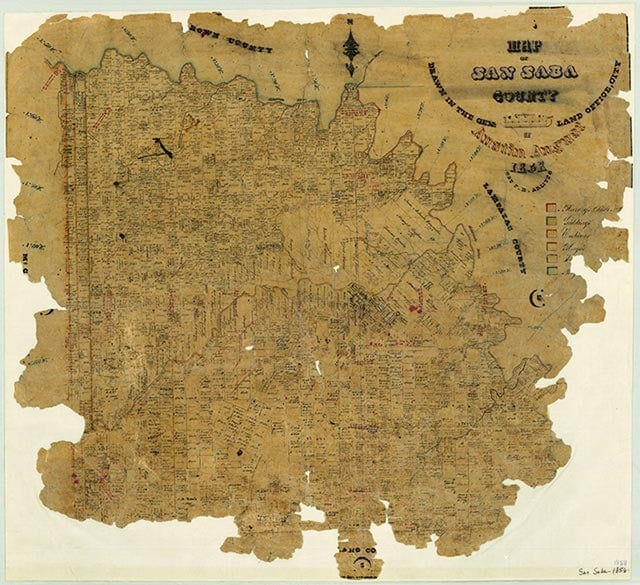
Archeological evidence indicates that Tonkawas, Apaches, Caddoans, and Comanches inhabited the area at different times. Comanches and Lipan Apaches continued to live in the San Saba County area into the eighteenth and nineteenth centuries, often coming into conflict with Spanish missionaries, United States military forces, and Anglo-American settlers. The first European exploration of the area occurred in 1732, when an expedition led by the Spanish governor of Texas, Juan Antonio Bustillo y Ceballos, passed through the vicinity. José Mares is also supposed to have crossed the area in 1788 on an expedition from San Antonio to Santa Fe. The original surveys of present San Saba County indicate that the first land grants, of a league each along the San Saba River, were given to Spanish grantees. The earliest known record of Anglo-Americans in San Saba County was in December 1828, when a group of twenty-eight citizens from Austin's colony at Gonzales traveled through the eastern area of the county on their way to recapture a band of horses. A part of the county was included in one of the grants ceded to Stephen F. Austin under the Mexican empresario system. The Beall grant, which overlapped the Austin grant, was another. In the case of these early grants individuals took legal but not physical possession of the land. The Fisher-Miller land grant, ceded by the Republic of Texas in 1842, can also be included in this category. Most of the later land deeds for San Saba County were out of the Fisher-Miller surveys, but the original members of this group of German-Texan pioneers did not stay in the area. Early permanent settlers included the Harkey family, who settled at Wallace and Richland creeks in the fall of 1854, and the David Matsler family, who moved from Burnet County and settled on Cherokee Creek that same year. San Saba County was organized in 1856 from Bexar County and was named for the San Saba River. The act establishing the county was passed by the Sixth Legislature and approved on February 1, 1856. The first election was held on May 3 to select county officers and a county seat. The results of this election were set aside because of irregularities, and another election was ordered. On July 19 the present site of the town of San Saba was selected for the county seat. Chappel, settled during the 1850s, was San Saba County's first town. Other towns founded at this time included Richland Springs, Sloan, Deer Creek, Colony, Harkeyville, and San Saba. Cherokee, Harmony Ridge, Holt, and Bend developed over the next twenty years. The original boundaries of the county were confirmed by the Seventh Legislature in 1858. During the Civil War the citizens of San Saba County supported the Confederacy. Although they held relatively few slaves, they favored states' rights. The majority of San Sabans who served in the Confederate forces were in the regiment of Col. James E. McCord. Their primary assignment was to protect the frontier, and they used Camp San Saba, a ranger station in McCulloch County, as their base of operations.
Victoria S. Murphy | © TSHA
Adapted from the official Handbook of Texas, a state encyclopedia developed by Texas State Historical Association (TSHA). It is an authoritative source of trusted historical records.
- ✅ Adoption Status:
- This place is available for adoption! Available for adoption!
- Adopted by:
- Your name goes here
- Dedication Message:
- Your message goes here
Currently Exists
Yes
Place type
San Saba County is classified as a County
Altitude Range
1020 ft – 1980 ft
Size
Land area does not include water surface area, whereas total area does
- Land Area: 1,135.3 mi²
- Total Area: 1,138.4 mi²
Temperature
January mean minimum:
34.6°F
July mean maximum:
95.7°F
Rainfall, 2019
28.5 inches
Population Count, 2019
6,055
Civilian Labor Count, 2019
29,112
Unemployment, 2019
5.0%
Property Values, 2019
$2,537,619,570 USD
Per-Capita Income, 2019
$41,233 USD
Retail Sales, 2019
$34,580,690 USD
Wages, 2019
$18,988,367 USD
County Map of Texas
San Saba County
- San Saba County
Places of San Saba County
| Place | Type | Population (Year/Source) | Currently Exists |
|---|---|---|---|
| Town | 10 (2009) | Yes | |
| Town | – | – | |
| Town | 115 (2009) | Yes | |
| Town | – | – | |
| Town | – | – | |
| Town | – | – | |
| Town | – | – | |
| Town | 20 (2009) | Yes | |
| Town | – | – | |
| Town | – | – | |
| Town | 25 (2014) | Yes | |
| Town | 175 (2014) | Yes | |
| Town | – | – | |
| Town | – | – | |
| Town | – | – | |
| Town | 15 (2009) | Yes | |
| Town | – | – | |
| Town | 15 (2009) | Yes | |
| Town | 12 (2014) | Yes | |
| Town | – | – | |
| Town | – | – | |
| Town | – | – | |
| Town | – | – | |
| Town | – | – | |
| Town | – | – | |
| Lake | – | Yes | |
| Town | 16 (2009) | Yes | |
| Town | – | – | |
| Town | – | – | |
| Town | 15 (2014) | Yes | |
| Town | – | – | |
| Town | – | – | |
| Town | – | – | |
| Town | – | – | |
| Town | – | – | |
| Town | – | – | |
| Town | – | – | |
| Town | 249 (2021) | Yes | |
| Town | – | – | |
| Town | – | – | |
| Town | 8 (2014) | Yes | |
| Town | – | – | |
| Town | 3,151 (2021) | Yes | |
| Town | – | – | |
| Town | – | – | |
| Town | – | – | |
| Town | 10 (2009) | Yes | |
| Town | 30 (2014) | Yes | |
| Town | 20 (2014) | Yes | |
| Town | – | – | |
| Town | – | – | |
| Town | – | – | |
| Town | – | – | |
| Town | – | – |
Photos Nearby:

San Saba, Texas
Image of the San Saba County Courthouse in San Saba, Texas, the county seat. Photograph by Aualliso.

Buchanan Dam was completed in 1938
Photo by Larry D. Moore, CC by SA 4.0
Proud to call Texas home?
Put your name on the town, county, or lake of your choice.
Search Places »