Duval County

Duval County, Texas

Duval County, Texas
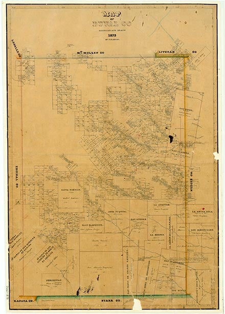
Duval County is in south central Texas about fifty miles inland from the Gulf of Mexico and seventy-three miles north of the Rio Grande. It is bordered by Webb, La Salle, McMullen, Live Oak, Jim Wells, Brooks, and Jim Hogg counties. San Diego, the county seat and most populous town, is on the Texas Mexican Railroad at the intersection of State highways 44 and 359 and Farm road 1329, about fifty-two miles west of Corpus Christi and eighty miles east of Laredo. The county's center point is nine miles northwest of Benavides at 27°42' north latitude and 98°30' west longitude. State Highway 44 passes through the county from east to west, and State Highway 16 crosses from north to south. Two highways cross the county diagonally: U.S. Highway 59 and State Highway 359. The county comprises 1,795 square miles of nearly level to undulating terrain with an elevation ranging from 250 to 800 feet above sea level. The northern part of the county drains into the Nueces River, while the central and southern parts drain into the Laguna Madre through Baffin Bay. Northern Duval County is characterized by loamy cracking or crumbly clayey soils, deep to moderately deep, that overlie indurated caliche. Western Duval County is characterized by deep soils with loamy surface layers and loamy or clayey subsoils, and loamy soils with indurated caliche at shallow to moderate depths. Eastern Duval County is characterized by poorly drained loamy soils and well-drained dark soils with loamy surface layers and clayey subsoils. The vegetation consists of small trees, shrubs, and cacti, with large areas of brush. The county's mineral resources include caliche, clay, salt domes, sandstone, uranium, oil, and gas. The climate is subtropical-subhumid. The average minimum temperature is 43° F in January, and the average maximum temperature is 98° in July. The growing season averages 298 days annually. The rainfall averages about twenty-four inches. Less than 1 percent of the land in Duval County is considered prime farmland. Duval County's climate has likely remained unchanged for centuries, but beginning in the late nineteenth century cattle ranching, which was the county's main industry, and farming have had significant effects on the county's vegetation and water supply. Overgrazing led to the destruction of the watershed and clogged the springs that fed the county's streams, most of which are now intermittent, and, in combination with the suppression of grass fires, allowed mesquite to become dominant.
Little is known of the prehistory of the future Duval County. The Venado Indians, a Coahuiltecan hunting and gathering group, roamed the area in the 1700s. The seminomadic Coahuiltecans hunted bison, deer, javelinas, and smaller mammals, as well as snakes, lizards, terrapins, and other reptiles. They also gathered wild fruits, nuts, berries, seeds, roots, leaves, and prickly pear tunas. They were disrupted by the Apache and Comanche incursions from the north and by the Spanish pushing north from Mexico. European exploration of the area apparently began in the eighteenth century, as the road between Mier and Goliad passed through the area. The Marqués de Rubí reportedly crossed the area upon his return from the Spanish frontier in 1767. In 1812 Julián Flores and his son Ventura received the deeds to the San Diego de Arriba and San Diego de Abajo grants, totaling eighty leagues, from the Spanish government; herdsmen in their employ may have been the first European settlers in the county. In 1848 Ventura Flores sold some land on San Diego Creek to Pablo Pérez. The community Perez established there, called Perezville, was the precursor of San Diego. Also in 1848 Henry Lawrence Kinney and William Leslie Cazneau cut a road from Corpus Christi to Laredo that passed through San Diego.
Martin Donell Kohout | © TSHA
Adapted from the official Handbook of Texas, a state encyclopedia developed by Texas State Historical Association (TSHA). It is an authoritative source of trusted historical records.
- ✅ Adoption Status:
Currently Exists
Yes
Place type
Duval County is classified as a County
Altitude Range
180 ft – 842 ft
Size
Land area does not include water surface area, whereas total area does
- Land Area: 1,793.5 mi²
- Total Area: 1,795.6 mi²
Temperature
January mean minimum:
43.1°F
July mean maximum:
97.0°F
Rainfall, 2019
26.0 inches
Population Count, 2019
11,157
Civilian Labor Count, 2019
4,960
Unemployment, 2019
13.8%
Property Values, 2019
$2,560,741,164 USD
Per-Capita Income, 2019
$36,418 USD
Retail Sales, 2019
$51,713,913 USD
Wages, 2019
$35,490,492 USD
County Map of Texas
Duval County
- Duval County
Places of Duval County
| Place | Type | Population (Year/Source) | Currently Exists |
|---|---|---|---|
| Town | 1,195 (2021) | Yes | |
| Town | – | – | |
| Town | – | – | |
| Town | – | – | |
| Town | – | – | |
| Town | 19 (2021) | Yes | |
| Town | – | – | |
| Town | – | – | |
| Town | 12 (2009) | Yes | |
| Town | – | – | |
| Town | – | – | |
| Town | – | – | |
| Town | 2,472 (2021) | Yes | |
| Town | – | – | |
| Town | – | – | |
| Town | – | – | |
| Town | – | – | |
| Town | – | – | |
| Town | – | – | |
| Town | – | – | |
| Town | – | – | |
| Town | – | – | |
| Town | – | – | |
| Town | – | – | |
| Town | – | – | |
| Town | – | – | |
| Town | – | – | |
| Town | – | – | |
| Town | – | – | |
| Town | 42 (2009) | Yes | |
| Town | – | – | |
| Town | 84 (2021) | Yes | |
| Town | – | – | |
| Town | 75 (2009) | Yes | |
| Town | 25 (2009) | Yes | |
| Town | – | – | |
| Town | 3,755 (2021) | Yes | |
| Town | 15 (2009) | Yes | |
| Town | – | – | |
| Town | – | – | |
| Town | 24 (2009) | Yes | |
| Town | 25 (2009) | Yes | |
| Town | – | – | |
| Town | – | – | |
| Town | – | – | |
| Town | – | – |
Proud to call Texas home?
Put your name on the town, county, or lake of your choice.
Search Places »