Calhoun County

Port O'Connor, Calhoun County, Texas

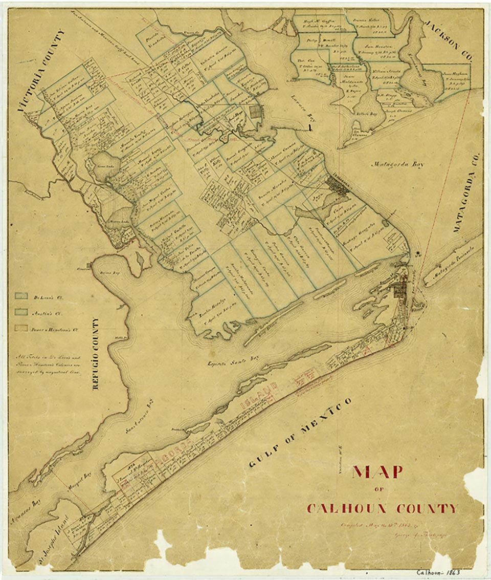
Calhoun County, Texas
Calhoun County is located on the Gulf Coast between Houston and Corpus Christi. Approximately one-fourth of the county's 540-square-mile area is under water. Calhoun County is bordered by Victoria and Jackson counties on the north, Matagorda Island and the Gulf on the south, Refugio County on the west, and Matagorda County on the east. The approximate center of the county is at 33°40' north latitude and 95°06' west longitude, five miles southwest of Port Lavaca, the county seat. The altitude of this Coastal Prairie county ranges from sea level to fifty feet. The terrain is flat, poorly to moderately well drained, and surfaced with loams underlain by cracking, clayey subsoils, including deep black soils and sandy clay. Matagorda Island, on the southern fringe of the county, is chiefly deep shell sand. The climate is mild, the rainfall averages about forty inches annually, and the growing season lasts 305 days a year. The flora includes tall grasses and live oaks with cordgrasses and sedges along the coast, and the animal life includes quail, deer, doves, cottontail rabbits, jackrabbits, armadillos, skunks, opossums, raccoons, and a few coyotes. Between 21 and 30 percent of the land is considered prime farmland. The county is drained by the Guadalupe River, Chocolate Bayou, and several creeks. Green Lake, a large natural lake, is in Calhoun County. Major incorporated communities include Point Comfort, Port Lavaca, and Seadrift. The county is served by the Union Pacific railroad, as well as by U.S. Highway 87 and State highways 35 and 185.
Evidence suggests that Calhoun County was inhabited from prehistoric times. A Clovis point is among examples of Paleo-American projectile points found in the area. Shell middens have been located at Mustang Lake, an arm of San Antonio Bay. Karankawa Indians populated the shoreline and roamed the Coastal Plain until the middle of the nineteenth century, when they were notorious among White settlers. Subgroups of the Karankawas occupied Matagorda Bay and Matagorda Peninsula. Fletching tools, scrapers, and spear and arrow points have been discovered at Lavaca Bay and Six Mile Creek. Tonkawa shelter sites have been found at Cox's Creek, Keller's Creek, and the mouth of the Guadalupe River, as well as on Green Lake, Chocolate Bayou, and Linn's Bayou in Port Lavaca.
Diana J. Kleiner | © TSHA
Adapted from the official Handbook of Texas, a state encyclopedia developed by Texas State Historical Association (TSHA). It is an authoritative source of trusted historical records.
- ✅ Adoption Status:
Currently Exists
Yes
Place type
Calhoun County is classified as a County
Altitude Range
0 ft – 56 ft
Size
Land area does not include water surface area, whereas total area does
- Land Area: 506.8 mi²
- Total Area: 1,032.7 mi²
Temperature
January mean minimum:
46.5°F
July mean maximum:
89.0°F
Rainfall, 2019
35.9 inches
Population Count, 2019
21,290
Civilian Labor Count, 2019
11,738
Unemployment, 2019
6.4%
Property Values, 2019
$4,015,528,575 USD
Per-Capita Income, 2019
$38,668 USD
Retail Sales, 2019
$249,332,009 USD
Wages, 2019
$239,876,483 USD
County Map of Texas
Calhoun County
- Calhoun County
Places of Calhoun County
| Place | Type | Population (Year/Source) | Currently Exists |
|---|---|---|---|
| Town | 454 (2021) | Yes | |
| Town | – | – | |
| Town | – | – | |
| Town | – | – | |
| Town | – | – | |
| Town | – | – | |
| Lake | – | Yes | |
| Town | – | – | |
| Town | – | – | |
| Town | – | – | |
| Town | 51 (2009) | Yes | |
| Town | – | – | |
| Town | – | – | |
| Town | – | – | |
| Town | 200 (2009) | Yes | |
| Town | 25 (2009) | Yes | |
| Town | – | – | |
| Town | – | – | |
| Town | – | – | |
| Town | 76 (2009) | Yes | |
| Town | – | – | |
| Town | 108 (2021) | Yes | |
| Town | – | – | |
| Town | – | – | |
| Town | – | – | |
| Town | 215 (2009) | Yes | |
| Town | – | – | |
| Town | 583 (2021) | Yes | |
| Town | 45 (2009) | Yes | |
| Town | 11,259 (2021) | Yes | |
| Town | 1,084 (2021) | Yes | |
| Town | – | – | |
| Town | – | – | |
| Town | – | – | |
| Town | – | – | |
| Town | – | – | |
| Town | 70 (2009) | Yes | |
| Town | 999 (2021) | Yes | |
| Town | 300 (2009) | Yes | |
| Town | – | – | |
| Town | – | – | |
| Lake | – | Yes |
Photos Nearby:

Port Lavaca, Texas
The Calhoun County Courthouse in Port Lavaca, Texas. Photograph by Larry D. Moore.

The Spillway at Lake Wright Patman
Lake Wright Patman's spillway was opened to control floodwaters in 2016. Photo by Griffinstorm, CC By SA 4.0
Proud to call Texas home?
Put your name on the town, county, or lake of your choice.
Search Places »