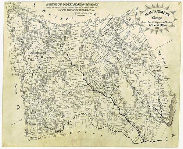
Montgomery County

Montgomery County, Texas

Montgomery County, Texas
Montgomery County is on Interstate 45 forty miles north of downtown Houston in the East Texas Timberlands Region. The center of the county is at 30°18' north latitude and 95°23' west longitude, near the county seat of Conroe. The county is bounded on the north by Walker and San Jacinto counties, on the east by Liberty County, on the south by Harris County, and on the west by Waller and Grimes counties. Montgomery County covers 1,047 square miles of flat to gently rolling terrain, with elevations ranging from 150 to 300 feet. To the south and west soils are light-colored and loamy with deep, reddish, clayey to loamy subsoils. The remainder of the county has reddish soils with loamy surfaces and very deep, clayey subsoils. Vegetation is typical of the Piney Woods area, with thick stands of longleaf, shortleaf, and loblolly pines and hickory, maple, sweet and black gum, oak, and magnolia trees. Grasses include Virginia wildrye, blackseed needlegrass, and purpletop. Wildlife in the county includes eastern gray and fox squirrels, various species of bats and skunks, and small herbivores such as gophers, mice, rabbits, and armadillos, as well as raccoons, white-tailed deer, opossum, bobcat, coyote, and red and grey fox. Alligators, frogs, toads, and numerous species of snake, including the poisonous copperhead, cottonmouth, coral snakes, and rattlesnake, are found in abundance. A wide variety of birds-mockingbirds, cardinals, doves, quail, bluejays, and roadrunners, to name a few-are also native to the area. Natural resources include timber, lakes, gravel, and oil; the Conroe oilfield was once the third largest in the United States. The county's principal water source is the San Jacinto River basin drainage system, which includes Peach, Caney, Spring, and Bushy creeks. The Lake Conroe Reservoir, seven miles northwest of Conroe, drains an area of 445 square miles; its surface area covers 20,118 acres, and its storage capacity is 380,400 acre-feet. The climate is subtropical humid, with warm summers and mild winters. The average annual relative humidity is 73 percent, and the average rainfall is 47.44 inches. The average annual temperature is 68° F. Temperatures in January range from an average low of 39° to an average high of 61° F and in July range from 72° to 95° F. The growing season averages 270 days per year, with the last freeze in early March and the first freeze in late November.
The area that now comprises Montgomery County has long been the site of human habitation. Numerous artifacts from the Paleo-Indian (10,000–6,000 B.C.) and Archaic (6,000–200 B.C.) cultures have been found in the area, suggesting that it has been continuously occupied for more than 10,000 years. When the first Europeans arrived in the region it was dominated by various tribes of the Atakapan Indians, a predominantly hunting and gathering people whose range extended south and eastward to the Gulf Coast. In the early eighteenth century one of these tribes, the Arkokisas (Orcoquisacs) had campsites along Peach Creek and on the banks of the San Jacinto River. The Bidai Indians, another Atakapan tribe, also ranged across most of the future county, their territory extending as far north as the Old San Antonio Road. Most of these native peoples eventually succumbed to European diseases, were killed by other Indian tribes, intermarried, or migrated elsewhere; by 1850 virtually no trace of them remained.
Christopher Long, Kameron K. Searle | © TSHA
Adapted from the official Handbook of Texas, a state encyclopedia developed by Texas State Historical Association (TSHA). It is an authoritative source of trusted historical records.
- ✅ Adoption Status:
Currently Exists
Yes
Place type
Montgomery County is classified as a County
Altitude Range
50 ft – 430 ft
Size
Land area does not include water surface area, whereas total area does
- Land Area: 1,041.7 mi²
- Total Area: 1,076.9 mi²
Temperature
January mean minimum:
40.4°F
July mean maximum:
93.5°F
Rainfall, 2019
48.8 inches
Population Count, 2019
607,391
Civilian Labor Count, 2019
278,703
Unemployment, 2019
8.7%
Property Values, 2019
$65,695,892,720 USD
Per-Capita Income, 2019
$63,605 USD
Retail Sales, 2019
$12,139,111,563 USD
Wages, 2019
$2,851,359,810 USD
County Map of Texas
Montgomery County
- Montgomery County
Places of Montgomery County
| Place | Type | Population (Year/Source) | Currently Exists |
|---|---|---|---|
| Town | – | – | |
| Town | – | – | |
| Town | – | – | |
| Town | – | – | |
| Town | – | – | |
| Town | – | – | |
| Town | – | – | |
| Town | – | – | |
| Town | – | – | |
| Town | – | – | |
| Town | – | – | |
| Town | – | – | |
| Town | – | – | |
| Town | – | – | |
| Town | – | – | |
| Town | – | – | |
| Town | – | – | |
| Town | – | – | |
| Town | – | – | |
| Town | – | – | |
| Town | – | – | |
| Town | – | – | |
| Town | 94,400 (2021) | Yes | |
| Town | – | – | |
| Town | – | – | |
| Town | – | – | |
| Town | – | – | |
| Town | – | – | |
| Town | 1,139 (2021) | Yes | |
| Town | 190 (2009) | Yes | |
| Town | – | – | |
| Town | 2,000 (2009) | Yes | |
| Town | 1,522 (2021) | Yes | |
| Town | 310 (2009) | Yes | |
| Town | – | – | |
| Town | – | – | |
| Town | – | – | |
| Town | – | – | |
| Town | – | – | |
| Town | 586 (2009) | Yes | |
| Town | 500 (2009) | Yes | |
| Town | – | – | |
| Town | – | – | |
| Town | 850 (2021) | Yes | |
| Town | – | – | |
| Town | – | – | |
| Town | – | – | |
| Town | – | – | |
| Town | – | – | |
| Town | – | – | |
| Town | – | – | |
| Town | – | – | |
| Town | – | – | |
| Town | – | – | |
| Town | – | – | |
| Town | 2,288,250 (2021) | Yes | |
| Town | – | – | |
| Town | – | – | |
| Town | – | – | |
| Town | – | – | |
| Town | – | – | |
| Town | – | – | |
| Town | – | – | |
| Town | – | – | |
| Town | – | Yes | |
| Town | – | – | |
| Lake | – | Yes | |
| Town | – | – | |
| Town | – | – | |
| Town | – | – | |
| Town | – | – | |
| Lake | – | Yes | |
| Town | – | – | |
| Town | – | – | |
| Town | – | – | |
| Town | 2,635 (2021) | Yes | |
| Town | – | – | |
| Town | – | – | |
| Town | – | – | |
| Town | – | – | |
| Town | – | – | |
| Town | – | – | |
| Town | – | – | |
| Town | – | – | |
| Town | – | – | |
| Town | 2,321 (2021) | Yes | |
| Town | – | – | |
| Town | 90 (2009) | Yes | |
| Town | – | – | |
| Town | – | – | |
| Town | 6,800 (2009) | Yes | |
| Town | 3,032 (2021) | Yes | |
| Town | 800 (2009) | Yes | |
| Town | – | – | |
| Town | 2,547 (2021) | Yes | |
| Town | 1,730 (2021) | Yes | |
| Town | – | – | |
| Town | – | – | |
| Town | – | – | |
| Town | 4,727 (2021) | Yes | |
| Town | – | – | |
| Town | – | – | |
| Town | – | – | |
| Town | – | – | |
| Town | 4,200 (2009) | Yes | |
| Town | 1,167 (2021) | Yes | |
| Town | – | – | |
| Town | – | – | |
| Town | – | – | |
| Town | – | – | |
| Town | – | – | |
| Town | – | – | |
| Town | – | – | |
| Town | 1,874 (2021) | Yes | |
| Town | – | – | |
| Town | – | – | |
| Town | – | – | |
| Town | – | – | |
| Town | 200 (2009) | Yes | |
| Town | – | – | |
| Town | 3,593 (2021) | Yes | |
| Town | – | – | |
| Town | – | – | |
| Town | 1,780 (2021) | Yes | |
| Town | 588 (2021) | Yes | |
| Town | – | – | |
| Town | 900 (2009) | Yes | |
| Town | – | – | |
| Town | – | – | |
| Town | – | – | |
| Town | 115,716 (2021) | Yes | |
| Town | – | – | |
| Town | – | – | |
| Town | – | – | |
| Town | – | – | |
| Town | – | – | |
| Town | – | – | |
| Town | – | – | |
| Town | – | – | |
| Town | – | – | |
| Town | – | – | |
| Town | 100 (2009) | Yes | |
| Town | – | – | |
| Town | 6,710 (2021) | Yes | |
| Town | – | – | |
| Town | 1,420 (2021) | Yes | |
| Town | 184 (2021) | Yes | |
| Town | – | – | |
| Town | – | – |
Photos Nearby:

The Arnold-Simonton House
Dr. E. J. Arnold, a prominent local physician, built this vernacular Greek Revival style house in 1845. The house was listed on the National Register of Historic Places on December 11, 1979. The house was moved from this location to the Fernland Historical Park in Montgomery after this photo was taken. Photo by Larry D. Moore, CC by 4.0

Conroe, Texas
View of downtown Conroe, the seat of Montgomery County, Texas. Photograph by HIM Nguyen.

Houston, Texas
Houston, Texas Photo by Efrain Alonso from Pexels

A beautiful morning on Lake Conroe
Photo by Katie Hougland Bowen, Flickr, CC2
Proud to call Texas home?
Put your name on the town, county, or lake of your choice.
Search Places »