Grayson County

Grayson County, Texas

Grayson County, Texas
Grayson County, in north central Texas, is bordered by the Red River and by Fannin, Collin, Denton, and Cooke counties. The county seat, Sherman, which lies approximately sixty-five miles north of Dallas, is part of the Sherman-Denison Metropolitan Statistical Area. The county's center point is at 33°40' north latitude and 96°40' west longitude. Grayson County, 934 square miles in area, has an elevation ranging from 600 to 800 feet and generally level terrain with some low hills. The northern part, which drains into Lake Texoma and the Red River, is characterized by acidic soils of the Post Oak Belt, with loamy or sandy surfaces. The southern areas, which drain to tributaries of the Trinity River, have blackland soils conducive to the growth of trees such as post oak, bois d'arc, elm, and walnut, as well as various types of grasses. Natural resources include limestone, oil and gas, bituminous coal, and sand and gravel. Grayson County is drained principally by Choctaw Creek and its two main tributaries, Post Oak and Iron Ore creeks. The county has an average annual precipitation of thirty-seven inches, temperatures ranging from an average low in January of 30° F to an average high of 96° in July, and a growing season that averages 227 days a year.
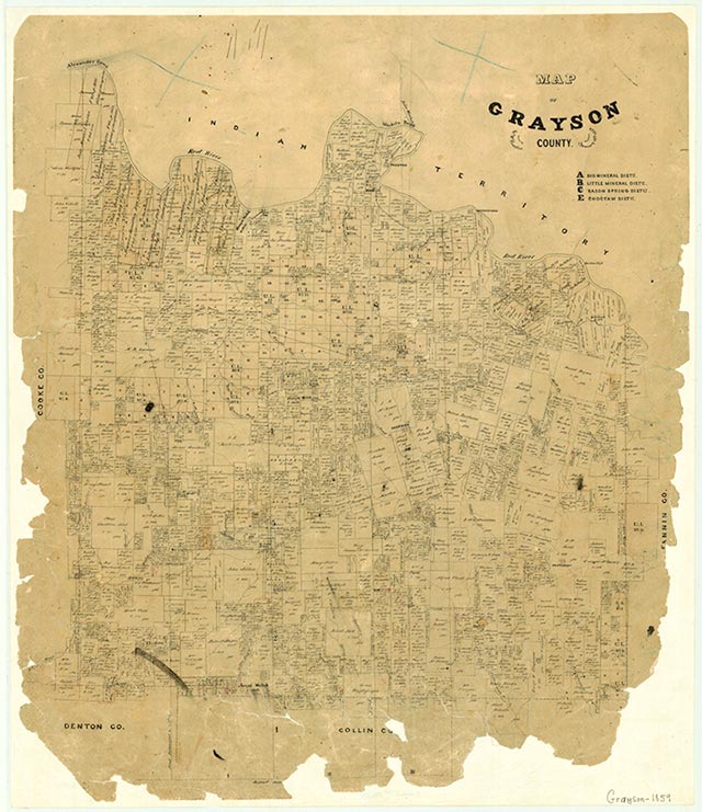
Various Caddo groups, including the Kichai, Ionis, and Tonkawa Indians, were the earliest known inhabitants of the area that became Grayson County. These Indians, agriculturalists who found the soils of the area suitable to their way of life, traded and negotiated with the Spanish and French, who moved up the Red River during the eighteenth century to establish trading posts. French and Spanish expeditions resulted in the initial settlements established in 1836–37 at Preston Bend on the Red River, at Pilot Grove in the southeastern part of the county, and at Warren. After the establishment and surveying of the Peters colony in the early 1840s, settlement of the region progressed rapidly. On March 17, 1846, Grayson County, named for Peter W. Grayson, attorney general of the Republic of Texas, was marked off from Fannin County. The legislative action also specified that the county seat be called Sherman. The naming of the county seat in honor of Gen. Sidney Sherman was apparently an effort to effect a compromise between supporters of Sherman, an anti-Houston Whig, and Grayson, a pro-Houston Democrat. Sherman has the distinction of being one of the few towns in the Lone Star State named by an act of the legislature.
Donna J. Kumler | © TSHA
Adapted from the official Handbook of Texas, a state encyclopedia developed by Texas State Historical Association (TSHA). It is an authoritative source of trusted historical records.
Currently Exists
Yes
Place type
Grayson County is classified as a County
Altitude Range
500 ft – 930 ft
Size
Land area does not include water surface area, whereas total area does
- Land Area: 932.8 mi²
- Total Area: 979.2 mi²
Temperature
January mean minimum:
33.1°F
July mean maximum:
92.1°F
Rainfall, 2019
43.6 inches
Population Count, 2019
136,212
Civilian Labor Count, 2019
63,050
Unemployment, 2019
6.8%
Property Values, 2019
$14,110,237,516 USD
Per-Capita Income, 2019
$42,195 USD
Retail Sales, 2019
$2,174,744,457 USD
Wages, 2019
$560,315,084 USD
County Map of Texas
Grayson County
- Grayson County
Places of Grayson County
| Place | Type | Population (Year/Source) | Currently Exists |
|---|---|---|---|
| Town | – | – | |
| Town | 90 (2014) | Yes | |
| Town | – | – | |
| Town | – | – | |
| Town | – | – | |
| Town | – | – | |
| Town | – | – | |
| Town | 1,540 (2021) | Yes | |
| Town | – | – | |
| Town | – | – | |
| Town | – | – | |
| Town | – | – | |
| Town | – | – | |
| Town | – | – | |
| Town | – | – | |
| Town | 50 (2014) | Yes | |
| Town | – | – | |
| Town | – | – | |
| Town | – | – | |
| Town | – | – | |
| Town | – | – | |
| Town | – | – | |
| Town | – | – | |
| Town | – | – | |
| Town | – | – | |
| Town | 1,931 (2021) | Yes | |
| Town | – | – | |
| Town | – | – | |
| Town | – | – | |
| Town | – | – | |
| Town | – | – | |
| Town | – | – | |
| Town | – | – | |
| Town | 25,179 (2021) | Yes | |
| Town | 17 (2014) | Yes | |
| Town | 69 (2021) | Yes | |
| Town | – | – | |
| Town | – | – | |
| Town | – | – | |
| Town | – | – | |
| Town | 15 (2014) | Yes | |
| Town | – | – | |
| Town | 40 (2014) | Yes | |
| Town | – | – | |
| Town | 40 (2014) | Yes | |
| Town | – | – | |
| Town | – | – | |
| Town | – | – | |
| Town | – | – | |
| Town | – | – | |
| Town | – | – | |
| Town | 165 (2014) | Yes | |
| Town | – | – | |
| Town | – | – | |
| Town | – | – | |
| Town | 2,255 (2021) | Yes | |
| Town | – | – | |
| Town | – | – | |
| Town | – | – | |
| Town | – | – | |
| Town | – | – | |
| Town | – | – | |
| Town | – | – | |
| Town | 3,615 (2021) | Yes | |
| Town | – | – | |
| Town | 30 (2014) | Yes | |
| Town | – | – | |
| Town | – | – | |
| Town | – | – | |
| Town | – | – | |
| Town | – | – | |
| Town | 20 (2009) | Yes | |
| Town | – | – | |
| Town | – | – | |
| Town | 776 (2021) | Yes | |
| Lake | – | Yes | |
| Town | – | – | |
| Town | – | – | |
| Town | – | – | |
| Town | 118 (2014) | Yes | |
| Town | – | – | |
| Town | 639 (2014) | Yes | |
| Town | – | – | |
| Town | – | – | |
| Town | – | – | |
| Town | – | – | |
| Town | – | – | |
| Town | – | – | |
| Town | – | – | |
| Town | – | – | |
| Town | – | – | |
| Town | – | – | |
| Town | – | – | |
| Town | – | – | |
| Town | 161 (2014) | Yes | |
| Town | – | – | |
| Town | – | – | |
| Town | – | – | |
| Town | – | – | |
| Town | 48 (2009) | Yes | |
| Town | – | – | |
| Town | – | – | |
| Town | 2,613 (2021) | Yes | |
| Town | 2,217 (2021) | Yes | |
| Town | – | – | |
| Lake | – | Yes | |
| Town | – | – | |
| Town | – | – | |
| Lake | – | Yes | |
| Town | – | – | |
| Town | – | – | |
| Town | – | – | |
| Town | – | – | |
| Town | – | – | |
| Town | – | – | |
| Town | 337 (2021) | Yes | |
| Town | – | – | |
| Town | 15 (2014) | Yes | |
| Town | – | – | |
| Town | – | – | |
| Town | 44,873 (2021) | Yes | |
| Town | 778 (2021) | Yes | |
| Town | – | – | |
| Town | – | – | |
| Town | 1,013 (2021) | Yes | |
| Town | – | – | |
| Town | – | – | |
| Town | – | – | |
| Town | – | – | |
| Town | – | – | |
| Town | – | – | |
| Town | – | – | |
| Town | – | – | |
| Town | – | – | |
| Town | – | – | |
| Town | 1,192 (2021) | Yes | |
| Town | – | – | |
| Town | – | – | |
| Town | 933 (2021) | Yes | |
| Town | – | – | |
| Town | – | – | |
| Town | – | – | |
| Lake | – | Yes | |
| Town | 5,165 (2021) | Yes | |
| Town | – | – | |
| Town | – | – | |
| Town | – | – | |
| Town | – | – | |
| Town | – | – | |
| Town | – | – | |
| Town | – | – | |
| Town | – | – | |
| Town | 4,217 (2021) | Yes | |
| Town | 1,753 (2021) | Yes | |
| Town | – | – | |
| Town | – | – |
Photos Nearby:

City of Denison, Grayson County, Texas
City of Denison in Grayson County, Texas. Photograph by Renelibrary.

Sherman, Grayson County, Texas
City Hall in the City of Sherman, seat of Grayson County, Texas. Photograph by Michael Barera.
.jpg)

Sightseers watching water on the spillway at Lake Texoma
Photo by Brendajane, Public Domain

Sunset over Ray Roberts Lake
Photo by Morcup, CC by SA 4
Proud to call Texas home?
Put your name on the town, county, or lake of your choice.
Search Places »