Upshur County

.jpg)
Upshur County, Texas

Upshur County, Texas
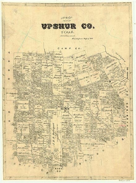
Upshur County is in northeastern Texas. The center of the county lies at 32°44' north latitude and 94°54' west longitude. Gilmer, the seat of government, is near the center of the county, twenty-three miles northwest of Longview. The county was named for Abel Parker Upshur, the secretary of state under President John Tyler. Upshur County encompasses 587 square miles of land that slopes gradually from northwest to southeast, with altitudes that range from 225 to 685 feet above sea level. It is in the Piney Woods vegetation region and is covered by grasslands; loblolly, shortleaf, longleaf, and slash pines; and hardwoods such as oak, hickory, and maple. Generally sandy, acidic, light-colored surface soils cover deep reddish, mottled subsoils. Upshur County straddles both of the major drainage systems of Texas. The northern portion drains into the Mississippi River via Little and Big Cypress creeks, while the waters of the southern portions flow to the Gulf of Mexico by means of the Sabine River, which forms the southwestern border of the county. The county has a subtropical humid climate and an average annual rainfall of 45.74 inches. Temperatures range from an average minimum of 37° F in January to an average maximum of 96° in July; the average growing season lasts 245 days. Prehistoric Upshur County was almost entirely forested with a blend of pine, maple, sweet and black gums, hickory, birch, ash, and many kinds of oaks, such as are found in the mixed deciduous-pine forests throughout the Eastern Woodlands region. The lumber industry has been a major operation from the early days of settlement, and none of the area's virgin forest now exists. In the 1980s more than half the county was forested. While the local flora and fauna generally belong to the mixtures common to the Mississippi Valley and the Eastern Woodlands, during the drought of the 1950s road runners, armadillos, and other species from West Texas migrated into the county and have since remained. Mineral resources include oil, natural gas, lignite, and industrial sand.
Artifacts dating from the Paleo-Indian period have been found in Upshur County, indicating that humans have lived in the area for perhaps 10,000 to 12,000 years. Caddoan Indian groups lived in the region during the Late Prehistoric period (1,150 to 250 years ago), but by the 1690s most of the Caddoans had disappeared, probably the victims of disease epidemics. By the 1820s and 1830s Cherokees had crossed into the area as they traveled from Oklahoma toward Nacogdoches using the route called the Cherokee Trace. By 1839, when the Cherokees were expelled from Texas, the area that is now Upshur County was at the intersection of two early immigration routes: the Cherokee Trace and the Jefferson-Dallas Road, which ran across the northern portion of the area. The first settler within the limits of modern Upshur County was probably Isaac Moody, who settled on the Cherokee Trace near West Mountain in 1836. The area that is now Upshur County was originally part of Nacogdoches County and later was incorporated into Harrison County. On April 27, 1846, after Texas was admitted to the Union, the first legislature of the state of Texas established Upshur County; at that time the county included the area of present Camp County and part of modern Gregg County. On May 1, 1848, the county's voters chose the location for Gilmer, the county seat, and in August the sale of blocks and lots in the new town began. Some of the earliest residents had been participants in the Regulator-Moderator War. John Hamilton McNairy, for example, signed the treaty that ended the war as a representative of the Regulators; in 1847 he bought land near Coffeeville and moved to Upshur County. McNairy was elected the first representative from the new county to the Texas legislature. Analysis of the 1850 and 1860 United States Census returns demonstrates that almost equal numbers of Tennesseans and Alabamans moved to the county during its early period. Planters from the Deep South tended to concentrate in the eastern half of the county, using their slaves to open up large tracts of land and to produce cotton. Meanwhile, farmers from the upper south who owned no slaves tended to settle in the western section of the county; they operated smaller, self-sustaining family farms and often lived in log cabins. One of the oldest churches in the county, the Enon Baptist Church of the Missionary Baptist Association, was organized on May 13, 1848; in 1849 the Hopewell Methodist Church organized and constructed its first building. Meanwhile other communities had begun to grow, including Ashland, Lafayette, and Shady Grove. By 1850 there were 3,934 people, including 682 slaves, living in Upshur County. According to the agricultural census for that year, local farmers produced 31,000 bushels of corn, 673 400-pound bales of cotton, and 1,061 pounds of tobacco, along with smaller amounts of wheat, rice, and oats. As the county grew and prospered, new social institutions evolved, and by the mid-1850s schools such as the Gilmer Masonic Female Institute, the Murray Institute, and the Gilmer Male Academy had been established. By 1860 the population had increased to 10,645, including 3,794 slaves. That year 404,000 bushels of corn and 8,000 bales of cotton were produced, and 11,000 cattle were also reported in the area. Lumbering was another important part of the local economy, and by the beginning of the Civil War there were ten to twelve water-powered lumber mills operating in the county.
Mary Laschinger Kirby | © TSHA
Adapted from the official Handbook of Texas, a state encyclopedia developed by Texas State Historical Association (TSHA). It is an authoritative source of trusted historical records.
- ✅ Adoption Status:
Currently Exists
Yes
Place type
Upshur County is classified as a County
Altitude Range
228 ft – 685 ft
Size
Land area does not include water surface area, whereas total area does
- Land Area: 583.0 mi²
- Total Area: 592.6 mi²
Temperature
January mean minimum:
31.4°F
July mean maximum:
93.4°F
Rainfall, 2019
47.1 inches
Population Count, 2019
41,753
Civilian Labor Count, 2019
17,085
Unemployment, 2019
9.0%
Property Values, 2019
$3,044,826,277 USD
Per-Capita Income, 2019
$36,645 USD
Retail Sales, 2019
$249,030,841 USD
Wages, 2019
$78,914,460 USD
County Map of Texas
Upshur County
- Upshur County
Places of Upshur County
| Place | Type | Population (Year/Source) | Currently Exists |
|---|---|---|---|
| Town | – | – | |
| Town | – | – | |
| Town | – | – | |
| Town | 45 (2009) | Yes | |
| Town | – | – | |
| Town | 75 (2009) | Yes | |
| Town | 110 (2009) | Yes | |
| Town | 1,263 (2021) | Yes | |
| Town | – | – | |
| Town | – | – | |
| Town | 20 (2009) | Yes | |
| Town | 75 (2009) | Yes | |
| Town | – | – | |
| Town | – | – | |
| Town | – | – | |
| Town | 100 (2009) | Yes | |
| Town | 50 (2009) | Yes | |
| Town | – | – | |
| Town | – | – | |
| Town | – | – | |
| Town | 780 (2021) | Yes | |
| Town | 50 (2009) | Yes | |
| Town | – | – | |
| Town | 30 (2009) | Yes | |
| Town | – | – | |
| Town | – | – | |
| Town | 35 (2009) | Yes | |
| Town | – | – | |
| Town | – | – | |
| Town | 585 (2009) | Yes | |
| Town | – | – | |
| Town | – | – | |
| Town | 922 (2021) | Yes | |
| Town | 50 (2009) | Yes | |
| Town | 25 (2009) | Yes | |
| Town | 204 (2009) | Yes | |
| Town | – | – | |
| Town | 20 (2009) | Yes | |
| Town | – | – | |
| Town | – | – | |
| Town | 25 (2009) | Yes | |
| Town | 4,894 (2021) | Yes | |
| Town | – | – | |
| Town | – | – | |
| Town | 6,137 (2021) | Yes | |
| Town | 150 (2009) | Yes | |
| Town | 100 (2009) | Yes | |
| Town | – | – | |
| Town | – | – | |
| Town | 20 (2009) | Yes | |
| Town | – | – | |
| Town | – | – | |
| Town | – | – | |
| Town | – | – | |
| Town | 45 (2009) | Yes | |
| Town | – | – | |
| Town | – | – | |
| Town | – | – | |
| Town | – | – | |
| Town | 50 (2009) | Yes | |
| Town | – | – | |
| Town | 80 (2009) | Yes | |
| Lake | – | Yes | |
| Lake | – | Yes | |
| Lake | – | Yes | |
| Town | – | – | |
| Town | 50 (2009) | Yes | |
| Town | – | – | |
| Town | – | – | |
| Town | – | – | |
| Town | – | – | |
| Town | – | – | |
| Town | – | – | |
| Town | – | – | |
| Town | – | – | |
| Town | – | – | |
| Town | – | – | |
| Town | – | – | |
| Town | – | – | |
| Town | 20 (2009) | Yes | |
| Town | 50 (2009) | Yes | |
| Town | – | – | |
| Town | – | – | |
| Town | – | – | |
| Town | – | – | |
| Town | – | – | |
| Town | 20 (2009) | Yes | |
| Town | – | – | |
| Town | – | – | |
| Town | – | – | |
| Town | – | – | |
| Town | 1,142 (2021) | Yes | |
| Town | 20 (2009) | Yes | |
| Town | – | – | |
| Town | 20 (2009) | Yes | |
| Town | – | – | |
| Town | 35 (2009) | Yes | |
| Town | – | – | |
| Town | 125 (2009) | Yes | |
| Town | – | – | |
| Town | 40 (2009) | Yes | |
| Town | 100 (2009) | Yes | |
| Town | 75 (2009) | Yes | |
| Town | – | – | |
| Town | – | – | |
| Town | 50 (2009) | Yes | |
| Town | 40 (2009) | Yes | |
| Town | 100 (2009) | Yes | |
| Town | – | – | |
| Town | 75 (2009) | Yes | |
| Town | – | – | |
| Town | – | – | |
| Town | 45 (2009) | Yes | |
| Town | – | – | |
| Town | – | – | |
| Town | – | – | |
| Town | – | – | |
| Town | – | – | |
| Town | – | – | |
| Town | – | – | |
| Town | – | – | |
| Town | 453 (2021) | Yes | |
| Town | – | – | |
| Town | – | – | |
| Town | 75 (2009) | Yes | |
| Town | – | – | |
| Town | – | – | |
| Town | 321 (2021) | Yes | |
| Town | 325 (2009) | Yes | |
| Town | 75 (2009) | Yes | |
| Town | – | – | |
| Town | – | – |
Photos Nearby:

Gilmer, Texas
Gilmer is the seat of Upshur County, Texas. Photograph by Michael Barera.
.jpg)

A view from the fishing pier on Lake Gilmer
Photo by Jdf088, CC 3

Sunset on Lake O' the Pines
Photo by Audreylski, CC3
Proud to call Texas home?
Put your name on the town, county, or lake of your choice.
Search Places »